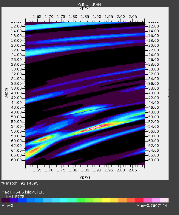
INU Inuyama, Japan - Earthquake Result Viewer

Earthquake location: Rat Islands, Aleutian Islands
Earthquake latitude/longitude: 51.2/178.7
Earthquake time(UTC): 1996/03/22 (082) 03:24:20 GMT
Earthquake Depth: 20 km
Earthquake Magnitude: 5.7 MB, 6.6 MS, 6.8 UNKNOWN, 6.6 ML
Earthquake Catalog/Contributor: WHDF/NEIC
Network: G GEOSCOPE
Station: INU Inuyama, Japan
Lat/Lon: 35.35 N/137.03 E
Elevation: 132 m
Distance: 33.7 deg
Az: 258.296 deg
Baz: 48.878 deg
Ray Param: 0.078061596
Estimated Moho Depth: 54.5 km
Estimated Crust Vp/Vs: 1.88
Assumed Crust Vp: 6.461 km/s
Estimated Crust Vs: 3.442 km/s
Estimated Crust Poisson's Ratio: 0.30
Radial Match: 92.14595 %
Radial Bump: 285
Transverse Match: 67.26094 %
Transverse Bump: 400
SOD ConfigId: 6273
Insert Time: 2010-02-26 23:16:18.150 +0000
GWidth: 2.5
Max Bumps: 400
Tol: 0.001

Signal To Noise

ChannelStoNSTALTA
G:INU: :BHN:19960322T03:30:29.148987Z5.96621231.4745442E-62.4714913E-7
G:INU: :BHE:19960322T03:30:29.148987Z5.3080281.5504854E-62.9210196E-7
G:INU: :BHZ:19960322T03:30:29.148987Z10.66774753.398821E-63.186072E-7
Arrivals
Ps8.0 SECOND
PpPs23 SECOND
PsPs/PpSs31 SECOND