You are here: Home > Network List > TA - USArray Transportable Network (new EarthScope stations) Stations List
> Station E31A Nome, ND, USA > Earthquake Result Viewer
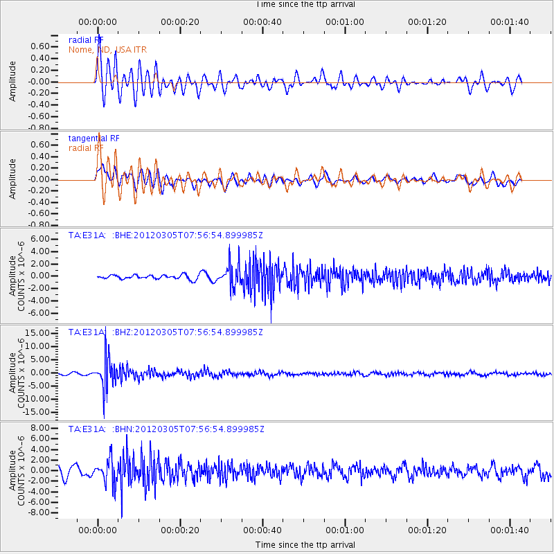
E31A Nome, ND, USA - Earthquake Result Viewer
*The percent match for this event was below the threshold and hence no stack was calculated.
| Earthquake location: |
Santiago Del Estero Prov., Arg. |
| Earthquake latitude/longitude: |
-28.2/-63.3 |
| Earthquake time(UTC): |
2012/03/05 (065) 07:46:10 GMT |
| Earthquake Depth: |
554 km |
| Earthquake Magnitude: |
6.0 MB, 6.1 MW, 6.1 MW |
| Earthquake Catalog/Contributor: |
WHDF/NEIC |
|
| Network: |
TA USArray Transportable Network (new EarthScope stations) |
| Station: |
E31A Nome, ND, USA |
| Lat/Lon: |
46.56 N/97.89 W |
| Elevation: |
427 m |
|
| Distance: |
80.8 deg |
| Az: |
336.614 deg |
| Baz: |
149.505 deg |
| Ray Param: |
$rayparam |
*The percent match for this event was below the threshold and hence was not used in the summary stack. |
|
| Radial Match: |
78.89939 % |
| Radial Bump: |
400 |
| Transverse Match: |
66.48898 % |
| Transverse Bump: |
400 |
| SOD ConfigId: |
440406 |
| Insert Time: |
2012-05-20 00:01:11.672 +0000 |
| GWidth: |
2.5 |
| Max Bumps: |
400 |
| Tol: |
0.001 |
|
Signal To Noise
| Channel | StoN | STA | LTA |
| TA:E31A: :BHZ:20120305T07:56:54.899985Z | 18.867817 | 5.692136E-6 | 3.016849E-7 |
| TA:E31A: :BHN:20120305T07:56:54.899985Z | 3.1979482 | 2.2168904E-6 | 6.932227E-7 |
| TA:E31A: :BHE:20120305T07:56:54.899985Z | 5.2307014 | 1.7692158E-6 | 3.3823682E-7 |
| Arrivals |
| Ps | |
| PpPs | |
| PsPs/PpSs | |


