You are here: Home > Network List > TA - USArray Transportable Network (new EarthScope stations) Stations List
> Station J37A Redenius Farm, Forest, IA, USA > Earthquake Result Viewer
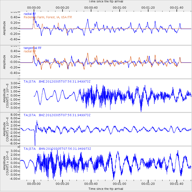
J37A Redenius Farm, Forest, IA, USA - Earthquake Result Viewer
*The percent match for this event was below the threshold and hence no stack was calculated.
| Earthquake location: |
Santiago Del Estero Prov., Arg. |
| Earthquake latitude/longitude: |
-28.2/-63.3 |
| Earthquake time(UTC): |
2012/03/05 (065) 07:46:10 GMT |
| Earthquake Depth: |
554 km |
| Earthquake Magnitude: |
6.0 MB, 6.1 MW, 6.1 MW |
| Earthquake Catalog/Contributor: |
WHDF/NEIC |
|
| Network: |
TA USArray Transportable Network (new EarthScope stations) |
| Station: |
J37A Redenius Farm, Forest, IA, USA |
| Lat/Lon: |
43.31 N/93.55 W |
| Elevation: |
385 m |
|
| Distance: |
76.4 deg |
| Az: |
337.767 deg |
| Baz: |
152.786 deg |
| Ray Param: |
$rayparam |
*The percent match for this event was below the threshold and hence was not used in the summary stack. |
|
| Radial Match: |
62.2952 % |
| Radial Bump: |
400 |
| Transverse Match: |
64.81934 % |
| Transverse Bump: |
400 |
| SOD ConfigId: |
440406 |
| Insert Time: |
2012-05-20 00:04:09.605 +0000 |
| GWidth: |
2.5 |
| Max Bumps: |
400 |
| Tol: |
0.001 |
|
Signal To Noise
| Channel | StoN | STA | LTA |
| TA:J37A: :BHZ:20120305T07:56:31.949973Z | 3.718237 | 2.4267215E-6 | 6.526538E-7 |
| TA:J37A: :BHN:20120305T07:56:31.949973Z | 0.98111516 | 1.2321549E-6 | 1.2558719E-6 |
| TA:J37A: :BHE:20120305T07:56:31.949973Z | 0.9032826 | 8.3434594E-7 | 9.2368214E-7 |
| Arrivals |
| Ps | |
| PpPs | |
| PsPs/PpSs | |


