You are here: Home > Network List > US - United States National Seismic Network Stations List
> Station EGMT Eagleton, Montana, USA > Earthquake Result Viewer
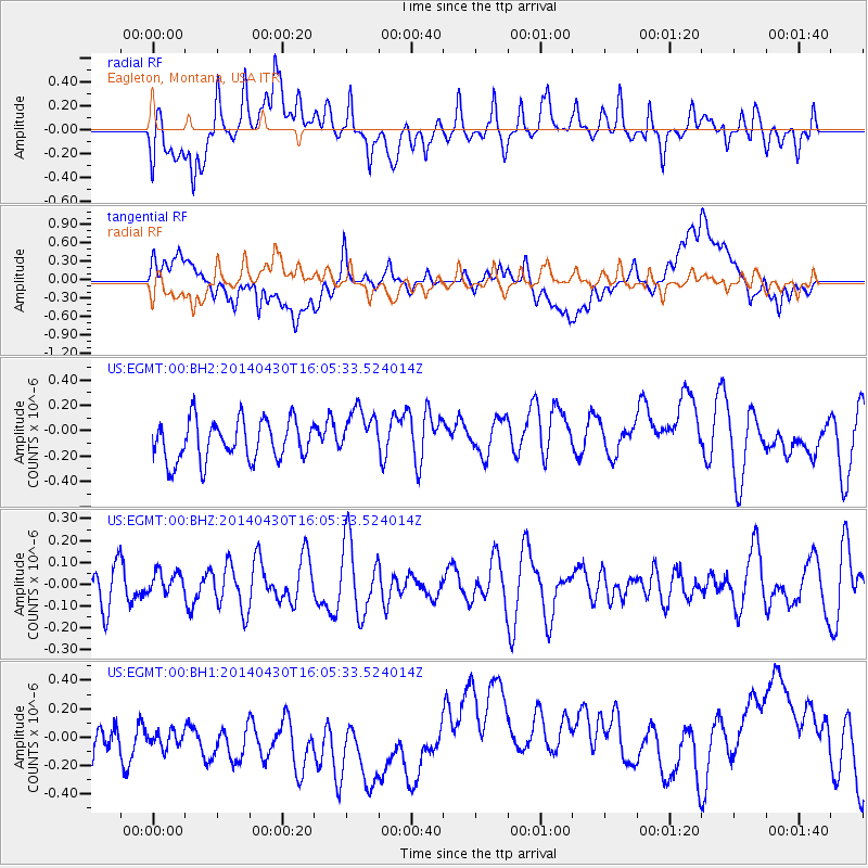
EGMT Eagleton, Montana, USA - Earthquake Result Viewer
*The percent match for this event was below the threshold and hence no stack was calculated.
| Earthquake location: |
North Of Ascension Island |
| Earthquake latitude/longitude: |
-1.2/-13.5 |
| Earthquake time(UTC): |
2014/04/30 (120) 15:52:42 GMT |
| Earthquake Depth: |
14 km |
| Earthquake Magnitude: |
5.8 MW |
| Earthquake Catalog/Contributor: |
ISC/ISC |
|
| Network: |
US United States National Seismic Network |
| Station: |
EGMT Eagleton, Montana, USA |
| Lat/Lon: |
48.02 N/109.75 W |
| Elevation: |
1055 m |
|
| Distance: |
95.1 deg |
| Az: |
317.935 deg |
| Baz: |
86.195 deg |
| Ray Param: |
$rayparam |
*The percent match for this event was below the threshold and hence was not used in the summary stack. |
|
| Radial Match: |
39.826286 % |
| Radial Bump: |
400 |
| Transverse Match: |
26.276793 % |
| Transverse Bump: |
400 |
| SOD ConfigId: |
3390531 |
| Insert Time: |
2019-04-11 15:49:14.738 +0000 |
| GWidth: |
2.5 |
| Max Bumps: |
400 |
| Tol: |
0.001 |
|
Signal To Noise
| Channel | StoN | STA | LTA |
| US:EGMT:00:BHZ:20140430T16:05:33.524014Z | 0.56445146 | 5.0995798E-8 | 9.0345765E-8 |
| US:EGMT:00:BH1:20140430T16:05:33.524014Z | 0.8248269 | 2.8637638E-7 | 3.4719574E-7 |
| US:EGMT:00:BH2:20140430T16:05:33.524014Z | 1.223836 | 1.9469876E-7 | 1.5908894E-7 |
| Arrivals |
| Ps | |
| PpPs | |
| PsPs/PpSs | |


