You are here: Home > Network List > TA - USArray Transportable Network (new EarthScope stations) Stations List
> Station S39A Bolivar, MO, USA > Earthquake Result Viewer
S39A Bolivar, MO, USA - Earthquake Result Viewer
*The percent match for this event was below the threshold and hence no stack was calculated.
| Earthquake location: |
Santiago Del Estero Prov., Arg. |
| Earthquake latitude/longitude: |
-28.2/-63.3 |
| Earthquake time(UTC): |
2012/03/05 (065) 07:46:10 GMT |
| Earthquake Depth: |
554 km |
| Earthquake Magnitude: |
6.0 MB, 6.1 MW, 6.1 MW |
| Earthquake Catalog/Contributor: |
WHDF/NEIC |
|
| Network: |
TA USArray Transportable Network (new EarthScope stations) |
| Station: |
S39A Bolivar, MO, USA |
| Lat/Lon: |
37.69 N/93.32 W |
| Elevation: |
331 m |
|
| Distance: |
71.4 deg |
| Az: |
335.233 deg |
| Baz: |
152.232 deg |
| Ray Param: |
$rayparam |
*The percent match for this event was below the threshold and hence was not used in the summary stack. |
|
| Radial Match: |
72.66229 % |
| Radial Bump: |
400 |
| Transverse Match: |
68.38436 % |
| Transverse Bump: |
400 |
| SOD ConfigId: |
440406 |
| Insert Time: |
2012-05-20 00:07:02.550 +0000 |
| GWidth: |
2.5 |
| Max Bumps: |
400 |
| Tol: |
0.001 |
|
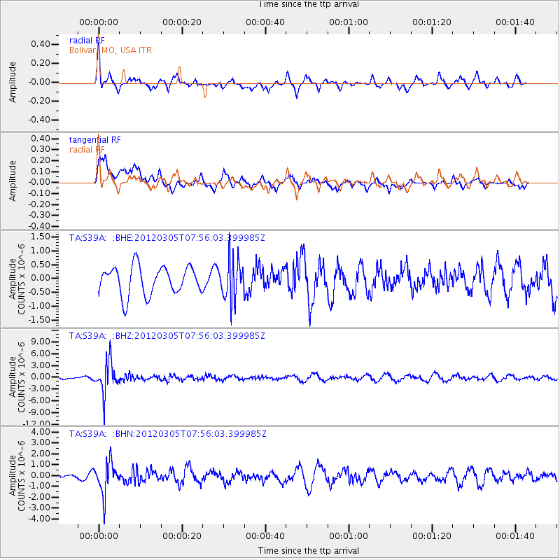
Signal To Noise
| Channel | StoN | STA | LTA |
| TA:S39A: :BHZ:20120305T07:56:03.399985Z | 7.6433992 | 3.9528595E-6 | 5.171599E-7 |
| TA:S39A: :BHN:20120305T07:56:03.399985Z | 7.2597947 | 1.4428375E-6 | 1.9874356E-7 |
| TA:S39A: :BHE:20120305T07:56:03.399985Z | 1.397681 | 7.1191437E-7 | 5.09354E-7 |
| Arrivals |
| Ps | |
| PpPs | |
| PsPs/PpSs | |


