You are here: Home > Network List > G - GEOSCOPE Stations List
> Station INU Inuyama, Japan > Earthquake Result Viewer
INU Inuyama, Japan - Earthquake Result Viewer

| Earthquake location: |
Fiji Islands Region |
| Earthquake latitude/longitude: |
-20.7/-178.3 |
| Earthquake time(UTC): |
1996/08/05 (218) 22:38:22 GMT |
| Earthquake Depth: |
550 km |
| Earthquake Magnitude: |
6.4 MB, 7.4 UNKNOWN, 7.3 MW |
| Earthquake Catalog/Contributor: |
WHDF/NEIC |
|
| Network: |
G GEOSCOPE |
| Station: |
INU Inuyama, Japan |
| Lat/Lon: |
35.35 N/137.03 E |
| Elevation: |
132 m |
|
| Distance: |
70.0 deg |
| Az: |
322.302 deg |
| Baz: |
135.542 deg |
| Ray Param: |
0.05340453 |
| Estimated Moho Depth: |
34.75 km |
| Estimated Crust Vp/Vs: |
2.07 |
| Assumed Crust Vp: |
6.461 km/s |
| Estimated Crust Vs: |
3.121 km/s |
| Estimated Crust Poisson's Ratio: |
0.35 |
|
| Radial Match: |
93.14857 % |
| Radial Bump: |
400 |
| Transverse Match: |
85.10442 % |
| Transverse Bump: |
400 |
| SOD ConfigId: |
6273 |
| Insert Time: |
2010-02-26 23:16:36.119 +0000 |
| GWidth: |
2.5 |
| Max Bumps: |
400 |
| Tol: |
0.001 |
|
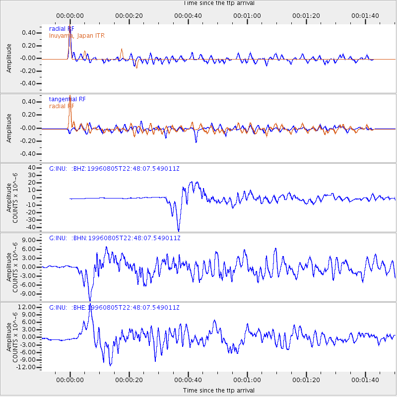
Signal To Noise
| Channel | StoN | STA | LTA |
| G:INU: :BHN:19960805T22:48:07.549011Z | 7.4213843 | 1.958953E-6 | 2.6396057E-7 |
| G:INU: :BHE:19960805T22:48:07.549011Z | 6.390402 | 2.25076E-6 | 3.5220944E-7 |
| G:INU: :BHZ:19960805T22:48:07.549011Z | 18.39104 | 7.8098365E-6 | 4.246544E-7 |
| Arrivals |
| Ps | 5.9 SECOND |
| PpPs | 16 SECOND |
| PsPs/PpSs | 22 SECOND |


