You are here: Home > Network List > TA - USArray Transportable Network (new EarthScope stations) Stations List
> Station J41A Loganville, WI, USA > Earthquake Result Viewer
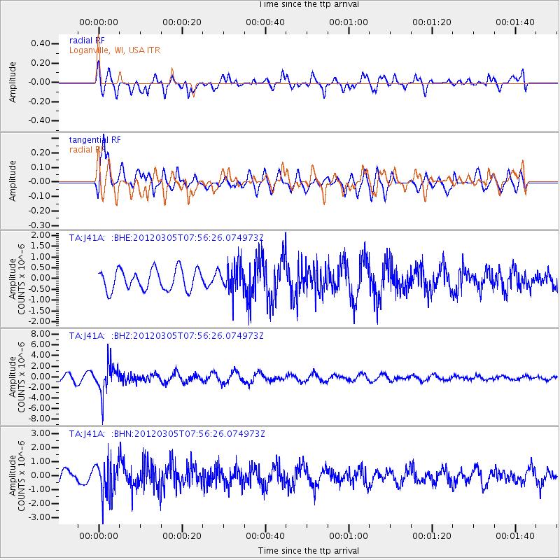
J41A Loganville, WI, USA - Earthquake Result Viewer
*The percent match for this event was below the threshold and hence no stack was calculated.
| Earthquake location: |
Santiago Del Estero Prov., Arg. |
| Earthquake latitude/longitude: |
-28.2/-63.3 |
| Earthquake time(UTC): |
2012/03/05 (065) 07:46:10 GMT |
| Earthquake Depth: |
554 km |
| Earthquake Magnitude: |
6.0 MB, 6.1 MW, 6.1 MW |
| Earthquake Catalog/Contributor: |
WHDF/NEIC |
|
| Network: |
TA USArray Transportable Network (new EarthScope stations) |
| Station: |
J41A Loganville, WI, USA |
| Lat/Lon: |
43.37 N/90.01 W |
| Elevation: |
360 m |
|
| Distance: |
75.4 deg |
| Az: |
340.19 deg |
| Baz: |
155.797 deg |
| Ray Param: |
$rayparam |
*The percent match for this event was below the threshold and hence was not used in the summary stack. |
|
| Radial Match: |
53.112194 % |
| Radial Bump: |
400 |
| Transverse Match: |
72.87846 % |
| Transverse Bump: |
400 |
| SOD ConfigId: |
440406 |
| Insert Time: |
2012-05-20 00:14:31.526 +0000 |
| GWidth: |
2.5 |
| Max Bumps: |
400 |
| Tol: |
0.001 |
|
Signal To Noise
| Channel | StoN | STA | LTA |
| TA:J41A: :BHZ:20120305T07:56:26.074973Z | 4.5442643 | 2.7090848E-6 | 5.961548E-7 |
| TA:J41A: :BHN:20120305T07:56:26.074973Z | 2.4802258 | 1.2577748E-6 | 5.0712106E-7 |
| TA:J41A: :BHE:20120305T07:56:26.074973Z | 1.3234868 | 6.2486595E-7 | 4.7213615E-7 |
| Arrivals |
| Ps | |
| PpPs | |
| PsPs/PpSs | |


