You are here: Home > Network List > TA - USArray Transportable Network (new EarthScope stations) Stations List
> Station P42A Winchester, IL, USA > Earthquake Result Viewer
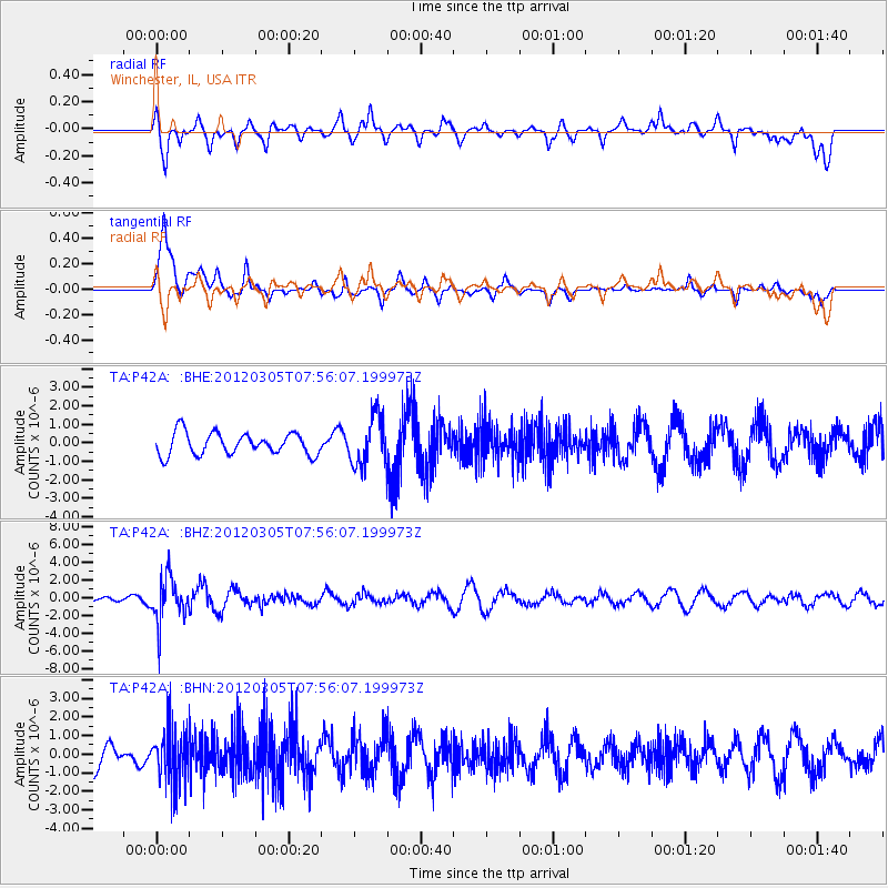
P42A Winchester, IL, USA - Earthquake Result Viewer
*The percent match for this event was below the threshold and hence no stack was calculated.
| Earthquake location: |
Santiago Del Estero Prov., Arg. |
| Earthquake latitude/longitude: |
-28.2/-63.3 |
| Earthquake time(UTC): |
2012/03/05 (065) 07:46:10 GMT |
| Earthquake Depth: |
554 km |
| Earthquake Magnitude: |
6.0 MB, 6.1 MW, 6.1 MW |
| Earthquake Catalog/Contributor: |
WHDF/NEIC |
|
| Network: |
TA USArray Transportable Network (new EarthScope stations) |
| Station: |
P42A Winchester, IL, USA |
| Lat/Lon: |
39.59 N/90.34 W |
| Elevation: |
197 m |
|
| Distance: |
72.0 deg |
| Az: |
338.319 deg |
| Baz: |
155.053 deg |
| Ray Param: |
$rayparam |
*The percent match for this event was below the threshold and hence was not used in the summary stack. |
|
| Radial Match: |
46.909466 % |
| Radial Bump: |
400 |
| Transverse Match: |
74.66032 % |
| Transverse Bump: |
387 |
| SOD ConfigId: |
440406 |
| Insert Time: |
2012-05-20 00:14:43.623 +0000 |
| GWidth: |
2.5 |
| Max Bumps: |
400 |
| Tol: |
0.001 |
|
Signal To Noise
| Channel | StoN | STA | LTA |
| TA:P42A: :BHZ:20120305T07:56:07.199973Z | 7.1401386 | 2.4976216E-6 | 3.4980016E-7 |
| TA:P42A: :BHN:20120305T07:56:07.199973Z | 1.2604502 | 1.4793017E-6 | 1.1736296E-6 |
| TA:P42A: :BHE:20120305T07:56:07.199973Z | 2.272829 | 1.351767E-6 | 5.947509E-7 |
| Arrivals |
| Ps | |
| PpPs | |
| PsPs/PpSs | |


