You are here: Home > Network List > TA - USArray Transportable Network (new EarthScope stations) Stations List
> Station F39A Loretta, WI, USA > Earthquake Result Viewer
F39A Loretta, WI, USA - Earthquake Result Viewer
*The percent match for this event was below the threshold and hence no stack was calculated.
| Earthquake location: |
Santiago Del Estero Prov., Arg. |
| Earthquake latitude/longitude: |
-28.2/-63.3 |
| Earthquake time(UTC): |
2012/03/05 (065) 07:46:10 GMT |
| Earthquake Depth: |
554 km |
| Earthquake Magnitude: |
6.0 MB, 6.1 MW, 6.1 MW |
| Earthquake Catalog/Contributor: |
WHDF/NEIC |
|
| Network: |
TA USArray Transportable Network (new EarthScope stations) |
| Station: |
F39A Loretta, WI, USA |
| Lat/Lon: |
45.92 N/90.92 W |
| Elevation: |
440 m |
|
| Distance: |
78.0 deg |
| Az: |
340.671 deg |
| Baz: |
155.274 deg |
| Ray Param: |
$rayparam |
*The percent match for this event was below the threshold and hence was not used in the summary stack. |
|
| Radial Match: |
46.479404 % |
| Radial Bump: |
328 |
| Transverse Match: |
55.0906 % |
| Transverse Bump: |
400 |
| SOD ConfigId: |
440406 |
| Insert Time: |
2012-05-20 00:17:49.672 +0000 |
| GWidth: |
2.5 |
| Max Bumps: |
400 |
| Tol: |
0.001 |
|
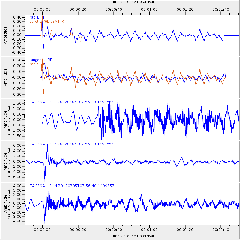
Signal To Noise
| Channel | StoN | STA | LTA |
| TA:F39A: :BHZ:20120305T07:56:40.149985Z | 5.586475 | 2.705879E-6 | 4.8436254E-7 |
| TA:F39A: :BHN:20120305T07:56:40.149985Z | 2.4619806 | 1.590406E-6 | 6.459864E-7 |
| TA:F39A: :BHE:20120305T07:56:40.149985Z | 1.6654661 | 6.8267275E-7 | 4.098989E-7 |
| Arrivals |
| Ps | |
| PpPs | |
| PsPs/PpSs | |


