You are here: Home > Network List > TA - USArray Transportable Network (new EarthScope stations) Stations List
> Station D41A Chassel, MI, USA > Earthquake Result Viewer
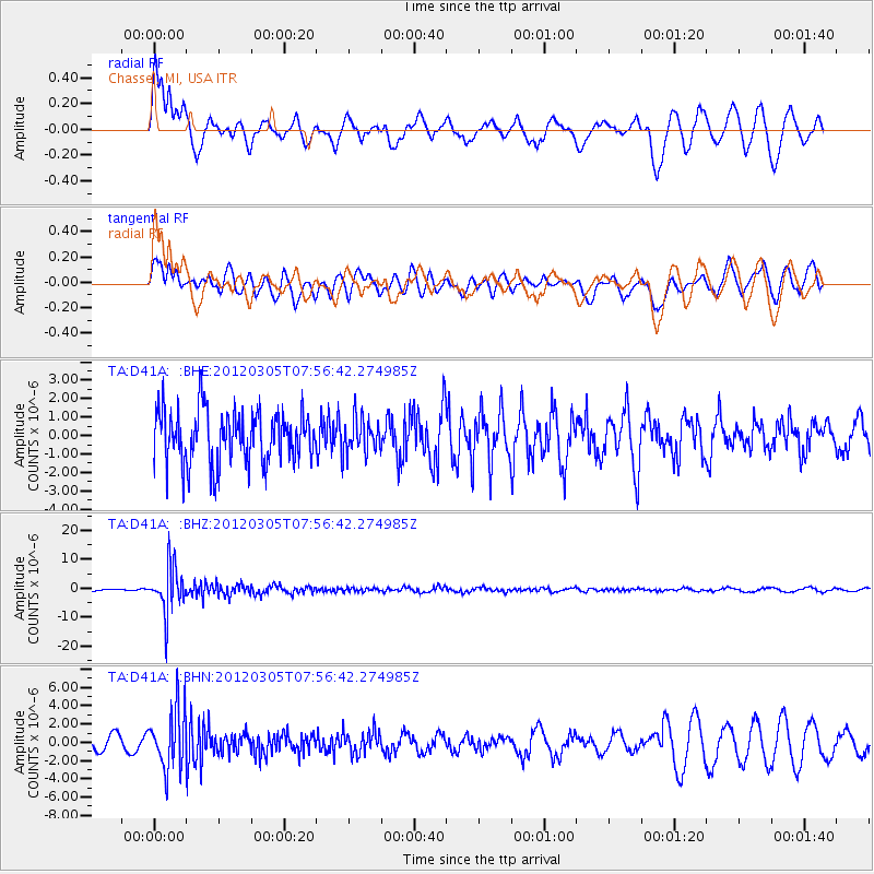
D41A Chassel, MI, USA - Earthquake Result Viewer
*The percent match for this event was below the threshold and hence no stack was calculated.
| Earthquake location: |
Santiago Del Estero Prov., Arg. |
| Earthquake latitude/longitude: |
-28.2/-63.3 |
| Earthquake time(UTC): |
2012/03/05 (065) 07:46:10 GMT |
| Earthquake Depth: |
554 km |
| Earthquake Magnitude: |
6.0 MB, 6.1 MW, 6.1 MW |
| Earthquake Catalog/Contributor: |
WHDF/NEIC |
|
| Network: |
TA USArray Transportable Network (new EarthScope stations) |
| Station: |
D41A Chassel, MI, USA |
| Lat/Lon: |
47.06 N/88.57 W |
| Elevation: |
271 m |
|
| Distance: |
78.4 deg |
| Az: |
342.662 deg |
| Baz: |
157.384 deg |
| Ray Param: |
$rayparam |
*The percent match for this event was below the threshold and hence was not used in the summary stack. |
|
| Radial Match: |
62.724716 % |
| Radial Bump: |
400 |
| Transverse Match: |
61.128307 % |
| Transverse Bump: |
400 |
| SOD ConfigId: |
440406 |
| Insert Time: |
2012-05-20 00:18:10.889 +0000 |
| GWidth: |
2.5 |
| Max Bumps: |
400 |
| Tol: |
0.001 |
|
Signal To Noise
| Channel | StoN | STA | LTA |
| TA:D41A: :BHZ:20120305T07:56:42.274985Z | 11.268828 | 7.771624E-6 | 6.8965676E-7 |
| TA:D41A: :BHN:20120305T07:56:42.274985Z | 3.238302 | 3.257883E-6 | 1.0060467E-6 |
| TA:D41A: :BHE:20120305T07:56:42.274985Z | 0.6585957 | 9.4697015E-7 | 1.4378626E-6 |
| Arrivals |
| Ps | |
| PpPs | |
| PsPs/PpSs | |


