You are here: Home > Network List > TA - USArray Transportable Network (new EarthScope stations) Stations List
> Station N45A Kentland, IN, USA > Earthquake Result Viewer
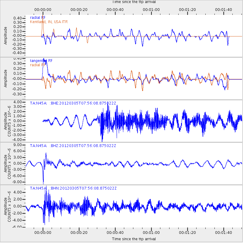
N45A Kentland, IN, USA - Earthquake Result Viewer
*The percent match for this event was below the threshold and hence no stack was calculated.
| Earthquake location: |
Santiago Del Estero Prov., Arg. |
| Earthquake latitude/longitude: |
-28.2/-63.3 |
| Earthquake time(UTC): |
2012/03/05 (065) 07:46:10 GMT |
| Earthquake Depth: |
554 km |
| Earthquake Magnitude: |
6.0 MB, 6.1 MW, 6.1 MW |
| Earthquake Catalog/Contributor: |
WHDF/NEIC |
|
| Network: |
TA USArray Transportable Network (new EarthScope stations) |
| Station: |
N45A Kentland, IN, USA |
| Lat/Lon: |
40.85 N/87.51 W |
| Elevation: |
206 m |
|
| Distance: |
72.3 deg |
| Az: |
340.937 deg |
| Baz: |
157.677 deg |
| Ray Param: |
$rayparam |
*The percent match for this event was below the threshold and hence was not used in the summary stack. |
|
| Radial Match: |
50.7183 % |
| Radial Bump: |
400 |
| Transverse Match: |
65.778145 % |
| Transverse Bump: |
400 |
| SOD ConfigId: |
440406 |
| Insert Time: |
2012-05-20 00:19:38.977 +0000 |
| GWidth: |
2.5 |
| Max Bumps: |
400 |
| Tol: |
0.001 |
|
Signal To Noise
| Channel | StoN | STA | LTA |
| TA:N45A: :BHZ:20120305T07:56:08.875022Z | 3.2597234 | 2.6121143E-6 | 8.0133003E-7 |
| TA:N45A: :BHN:20120305T07:56:08.875022Z | 3.865955 | 2.1410615E-6 | 5.5382475E-7 |
| TA:N45A: :BHE:20120305T07:56:08.875022Z | 1.9273747 | 1.3686102E-6 | 7.1009043E-7 |
| Arrivals |
| Ps | |
| PpPs | |
| PsPs/PpSs | |


