You are here: Home > Network List > G - GEOSCOPE Stations List
> Station INU Inuyama, Japan > Earthquake Result Viewer
INU Inuyama, Japan - Earthquake Result Viewer

| Earthquake location: |
Hindu Kush Region, Afghanistan |
| Earthquake latitude/longitude: |
36.4/70.9 |
| Earthquake time(UTC): |
1997/05/13 (133) 14:13:45 GMT |
| Earthquake Depth: |
196 km |
| Earthquake Magnitude: |
6.1 MB, 6.5 UNKNOWN, 6.4 MW |
| Earthquake Catalog/Contributor: |
WHDF/NEIC |
|
| Network: |
G GEOSCOPE |
| Station: |
INU Inuyama, Japan |
| Lat/Lon: |
35.35 N/137.03 E |
| Elevation: |
132 m |
|
| Distance: |
52.6 deg |
| Az: |
70.217 deg |
| Baz: |
291.787 deg |
| Ray Param: |
0.06596915 |
| Estimated Moho Depth: |
30.5 km |
| Estimated Crust Vp/Vs: |
1.63 |
| Assumed Crust Vp: |
6.461 km/s |
| Estimated Crust Vs: |
3.952 km/s |
| Estimated Crust Poisson's Ratio: |
0.20 |
|
| Radial Match: |
92.405045 % |
| Radial Bump: |
376 |
| Transverse Match: |
86.5661 % |
| Transverse Bump: |
400 |
| SOD ConfigId: |
6273 |
| Insert Time: |
2010-02-26 23:17:00.647 +0000 |
| GWidth: |
2.5 |
| Max Bumps: |
400 |
| Tol: |
0.001 |
|
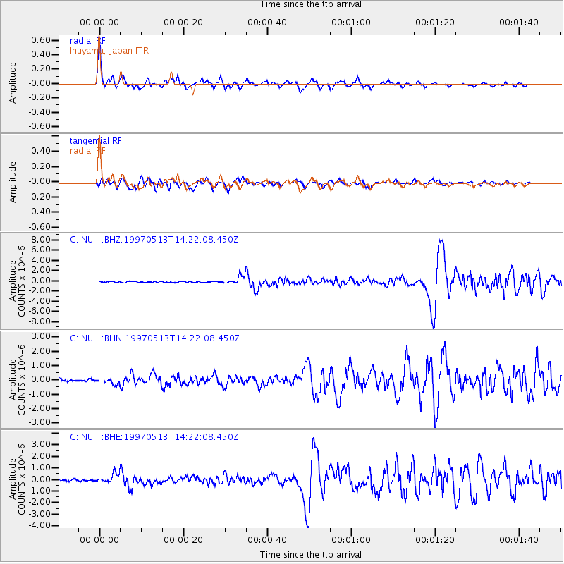
Signal To Noise
| Channel | StoN | STA | LTA |
| G:INU: :BHN:19970513T14:22:08.450Z | 1.6528403 | 1.8088632E-7 | 1.0943969E-7 |
| G:INU: :BHE:19970513T14:22:08.450Z | 5.1555824 | 4.039496E-7 | 7.835188E-8 |
| G:INU: :BHZ:19970513T14:22:08.450Z | 11.749785 | 8.154229E-7 | 6.939896E-8 |
| Arrivals |
| Ps | 3.2 SECOND |
| PpPs | 12 SECOND |
| PsPs/PpSs | 15 SECOND |


