You are here: Home > Network List > CB - China National Seismic Network Stations List
> Station DL2 Dalian,Liaoning Province > Earthquake Result Viewer
DL2 Dalian,Liaoning Province - Earthquake Result Viewer
| Earthquake location: |
Southeast Of Loyalty Islands |
| Earthquake latitude/longitude: |
-21.5/170.2 |
| Earthquake time(UTC): |
2014/05/01 (121) 06:36:37 GMT |
| Earthquake Depth: |
118 km |
| Earthquake Magnitude: |
6.7 MWP, 6.7 MI |
| Earthquake Catalog/Contributor: |
NEIC PDE/NEIC COMCAT |
|
| Network: |
CB China National Seismic Network |
| Station: |
DL2 Dalian,Liaoning Province |
| Lat/Lon: |
38.91 N/121.63 E |
| Elevation: |
65 m |
|
| Distance: |
75.4 deg |
| Az: |
322.788 deg |
| Baz: |
133.799 deg |
| Ray Param: |
0.051429395 |
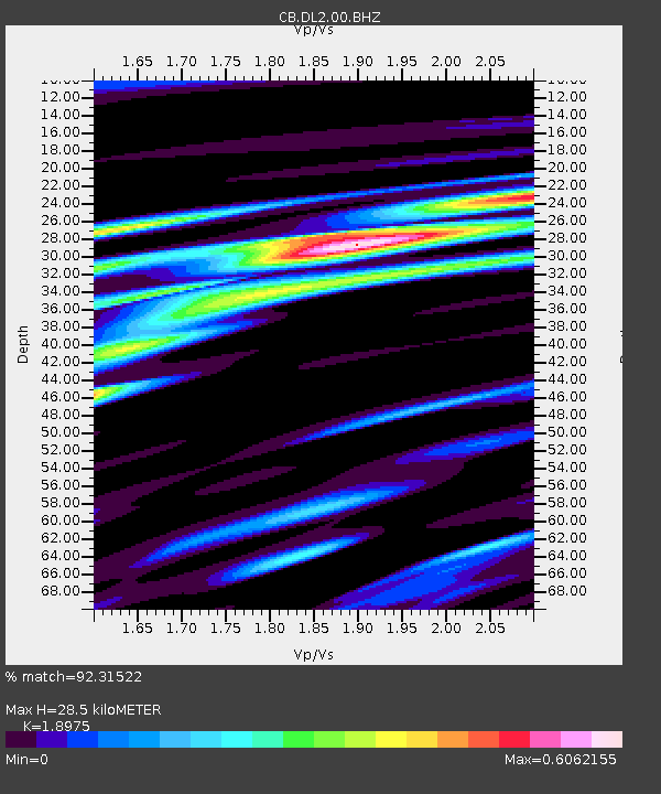
| Estimated Moho Depth: |
28.5 km |
| Estimated Crust Vp/Vs: |
1.90 |
| Assumed Crust Vp: |
6.134 km/s |
| Estimated Crust Vs: |
3.233 km/s |
| Estimated Crust Poisson's Ratio: |
0.31 |
|
| Radial Match: |
92.31522 % |
| Radial Bump: |
318 |
| Transverse Match: |
88.0256 % |
| Transverse Bump: |
361 |
| SOD ConfigId: |
3390531 |
| Insert Time: |
2019-04-11 15:53:04.961 +0000 |
| GWidth: |
2.5 |
| Max Bumps: |
400 |
| Tol: |
0.001 |
|

Signal To Noise
| Channel | StoN | STA | LTA |
| CB:DL2:00:BHZ:20140501T06:47:36.630012Z | 90.14107 | 9.1036345E-6 | 1.0099319E-7 |
| CB:DL2:00:BHN:20140501T06:47:36.630012Z | 28.505976 | 2.7533717E-6 | 9.6589275E-8 |
| CB:DL2:00:BHE:20140501T06:47:36.630012Z | 46.527668 | 3.2972016E-6 | 7.086539E-8 |
| Arrivals |
| Ps | 4.3 SECOND |
| PpPs | 13 SECOND |
| PsPs/PpSs | 17 SECOND |


