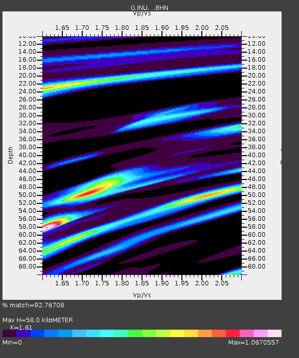
INU Inuyama, Japan - Earthquake Result Viewer
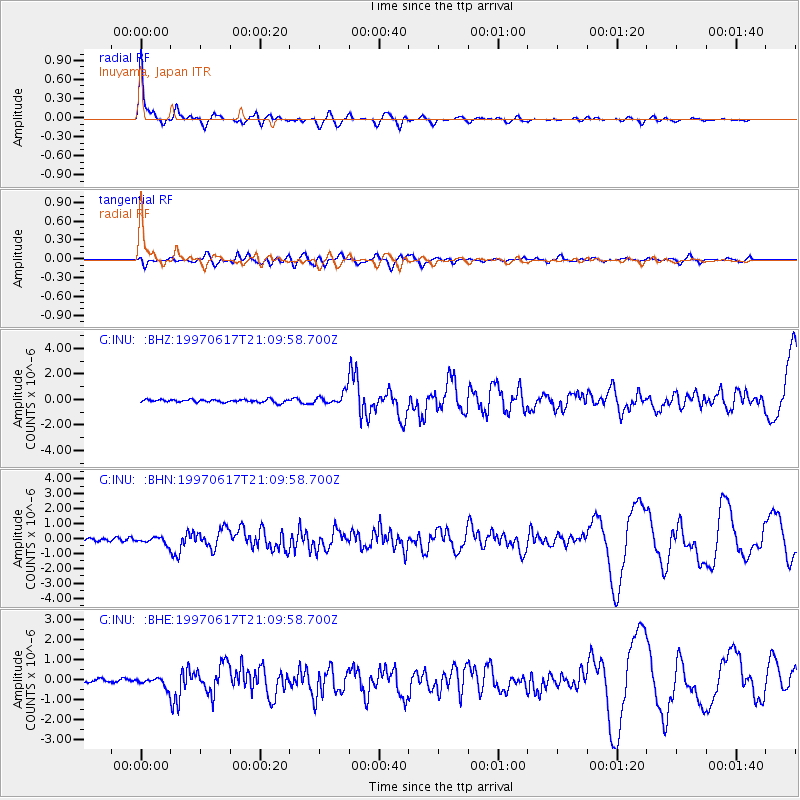
Earthquake location: Andreanof Islands, Aleutian Is.
Earthquake latitude/longitude: 51.3/-179.3
Earthquake time(UTC): 1997/06/17 (168) 21:03:40 GMT
Earthquake Depth: 33 km
Earthquake Magnitude: 6.4 MB, 6.3 MS, 6.4 UNKNOWN, 6.6 ML
Earthquake Catalog/Contributor: WHDF/NEIC
Network: G GEOSCOPE
Station: INU Inuyama, Japan
Lat/Lon: 35.35 N/137.03 E
Elevation: 132 m
Distance: 34.9 deg
Az: 259.992 deg
Baz: 49.072 deg
Ray Param: 0.07741808
Estimated Moho Depth: 58.0 km
Estimated Crust Vp/Vs: 1.61
Assumed Crust Vp: 6.461 km/s
Estimated Crust Vs: 4.013 km/s
Estimated Crust Poisson's Ratio: 0.19
Radial Match: 92.76708 %
Radial Bump: 370
Transverse Match: 81.50589 %
Transverse Bump: 400
SOD ConfigId: 6273
Insert Time: 2010-02-26 23:17:06.576 +0000
GWidth: 2.5
Max Bumps: 400
Tol: 0.001

Signal To Noise

ChannelStoNSTALTA
G:INU: :BHN:19970617T21:09:58.700Z1.41316762.2519457E-71.5935447E-7
G:INU: :BHE:19970617T21:09:58.700Z2.82599642.2871993E-78.0934264E-8
G:INU: :BHZ:19970617T21:09:58.700Z4.026244.5810333E-71.1377944E-7
Arrivals
Ps6.0 SECOND
PpPs22 SECOND
PsPs/PpSs27 SECOND