You are here: Home > Network List > NY - Yukon Northwest Seismic Network(YNSN) Stations List
> Station MAYO Mayo, Yukon, CANADA > Earthquake Result Viewer
MAYO Mayo, Yukon, CANADA - Earthquake Result Viewer
| Earthquake location: |
Southeast Of Loyalty Islands |
| Earthquake latitude/longitude: |
-21.5/170.2 |
| Earthquake time(UTC): |
2014/05/01 (121) 06:36:37 GMT |
| Earthquake Depth: |
118 km |
| Earthquake Magnitude: |
6.7 MWP, 6.7 MI |
| Earthquake Catalog/Contributor: |
NEIC PDE/NEIC COMCAT |
|
| Network: |
NY Yukon Northwest Seismic Network(YNSN) |
| Station: |
MAYO Mayo, Yukon, CANADA |
| Lat/Lon: |
63.60 N/135.89 W |
| Elevation: |
0.0 m |
|
| Distance: |
94.6 deg |
| Az: |
21.247 deg |
| Baz: |
229.006 deg |
| Ray Param: |
0.040910807 |
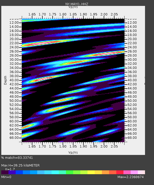
| Estimated Moho Depth: |
39.25 km |
| Estimated Crust Vp/Vs: |
1.70 |
| Assumed Crust Vp: |
6.419 km/s |
| Estimated Crust Vs: |
3.776 km/s |
| Estimated Crust Poisson's Ratio: |
0.24 |
|
| Radial Match: |
83.33741 % |
| Radial Bump: |
400 |
| Transverse Match: |
59.475773 % |
| Transverse Bump: |
400 |
| SOD ConfigId: |
3390531 |
| Insert Time: |
2019-04-11 15:54:26.633 +0000 |
| GWidth: |
2.5 |
| Max Bumps: |
400 |
| Tol: |
0.001 |
|

Signal To Noise
| Channel | StoN | STA | LTA |
| NY:MAYO: :HHZ:20140501T06:49:12.789985Z | 15.9661045 | 1.2310383E-6 | 7.710324E-8 |
| NY:MAYO: :HHN:20140501T06:49:12.789985Z | 3.0277221 | 4.1256303E-7 | 1.3626185E-7 |
| NY:MAYO: :HHE:20140501T06:49:12.789985Z | 3.0284164 | 4.581614E-7 | 1.5128745E-7 |
| Arrivals |
| Ps | 4.4 SECOND |
| PpPs | 16 SECOND |
| PsPs/PpSs | 21 SECOND |


