You are here: Home > Network List > UW - Pacific Northwest Regional Seismic Network Stations List
> Station MRBL Marblemount, WA, USA > Earthquake Result Viewer
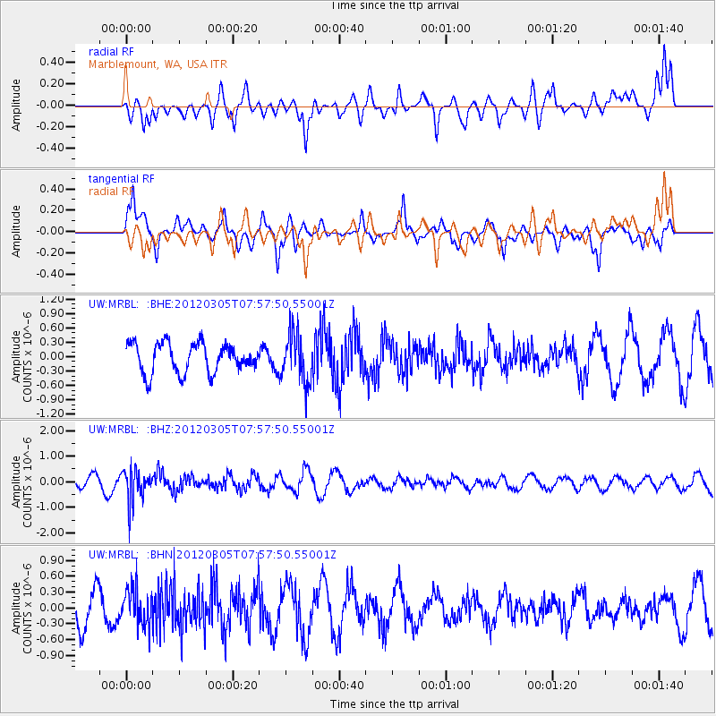
MRBL Marblemount, WA, USA - Earthquake Result Viewer
*The percent match for this event was below the threshold and hence no stack was calculated.
| Earthquake location: |
Santiago Del Estero Prov., Arg. |
| Earthquake latitude/longitude: |
-28.2/-63.3 |
| Earthquake time(UTC): |
2012/03/05 (065) 07:46:10 GMT |
| Earthquake Depth: |
554 km |
| Earthquake Magnitude: |
6.0 MB, 6.1 MW, 6.1 MW |
| Earthquake Catalog/Contributor: |
WHDF/NEIC |
|
| Network: |
UW Pacific Northwest Regional Seismic Network |
| Station: |
MRBL Marblemount, WA, USA |
| Lat/Lon: |
48.52 N/121.48 W |
| Elevation: |
75 m |
|
| Distance: |
92.4 deg |
| Az: |
325.561 deg |
| Baz: |
131.374 deg |
| Ray Param: |
$rayparam |
*The percent match for this event was below the threshold and hence was not used in the summary stack. |
|
| Radial Match: |
56.486824 % |
| Radial Bump: |
400 |
| Transverse Match: |
54.21656 % |
| Transverse Bump: |
400 |
| SOD ConfigId: |
440406 |
| Insert Time: |
2012-05-20 00:26:19.106 +0000 |
| GWidth: |
2.5 |
| Max Bumps: |
400 |
| Tol: |
0.001 |
|
Signal To Noise
| Channel | StoN | STA | LTA |
| UW:MRBL: :BHZ:20120305T07:57:50.55001Z | 4.4088383 | 6.228156E-7 | 1.4126525E-7 |
| UW:MRBL: :BHN:20120305T07:57:50.55001Z | 1.3005452 | 3.3740486E-7 | 2.594334E-7 |
| UW:MRBL: :BHE:20120305T07:57:50.55001Z | 1.7082211 | 5.214134E-7 | 3.052377E-7 |
| Arrivals |
| Ps | |
| PpPs | |
| PsPs/PpSs | |


