You are here: Home > Network List > TO - Tectonic Observatory Stations List
> Station CC11 CCSE CC11 > Earthquake Result Viewer
CC11 CCSE CC11 - Earthquake Result Viewer
| Earthquake location: |
Southeast Of Loyalty Islands |
| Earthquake latitude/longitude: |
-21.5/170.2 |
| Earthquake time(UTC): |
2014/05/01 (121) 06:36:37 GMT |
| Earthquake Depth: |
118 km |
| Earthquake Magnitude: |
6.7 MWP, 6.7 MI |
| Earthquake Catalog/Contributor: |
NEIC PDE/NEIC COMCAT |
|
| Network: |
TO Tectonic Observatory |
| Station: |
CC11 CCSE CC11 |
| Lat/Lon: |
36.06 N/120.75 W |
| Elevation: |
356 m |
|
| Distance: |
86.8 deg |
| Az: |
49.268 deg |
| Baz: |
240.564 deg |
| Ray Param: |
0.043554474 |
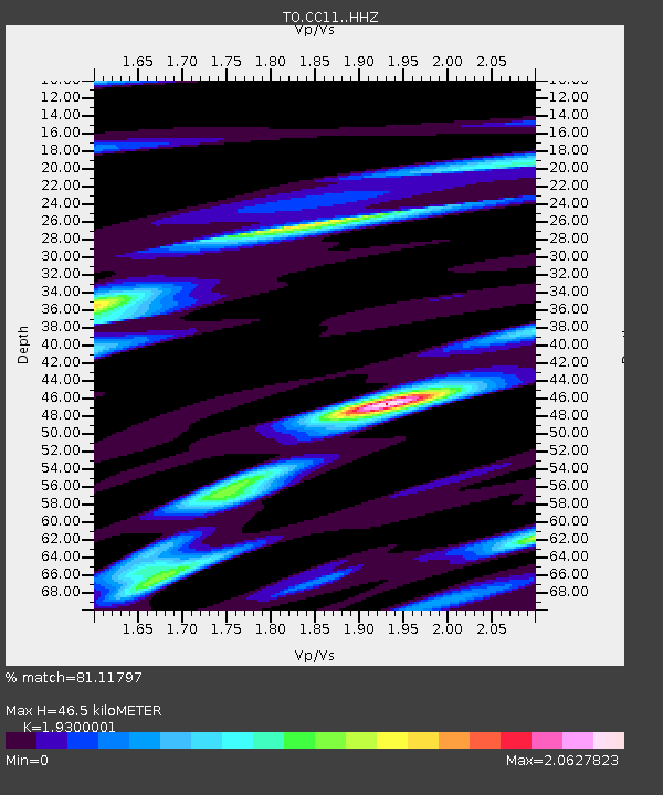
| Estimated Moho Depth: |
46.5 km |
| Estimated Crust Vp/Vs: |
1.93 |
| Assumed Crust Vp: |
6.391 km/s |
| Estimated Crust Vs: |
3.311 km/s |
| Estimated Crust Poisson's Ratio: |
0.32 |
|
| Radial Match: |
81.11797 % |
| Radial Bump: |
400 |
| Transverse Match: |
75.32255 % |
| Transverse Bump: |
400 |
| SOD ConfigId: |
3390531 |
| Insert Time: |
2019-04-11 15:55:02.841 +0000 |
| GWidth: |
2.5 |
| Max Bumps: |
400 |
| Tol: |
0.001 |
|

Signal To Noise
| Channel | StoN | STA | LTA |
| TO:CC11: :HHZ:20140501T06:48:36.210029Z | 5.348665 | 1.8565439E-6 | 3.4710416E-7 |
| TO:CC11: :HHN:20140501T06:48:36.210029Z | 2.4538233 | 6.2391393E-7 | 2.5426198E-7 |
| TO:CC11: :HHE:20140501T06:48:36.210029Z | 2.0343397 | 5.7221837E-7 | 2.8127968E-7 |
| Arrivals |
| Ps | 6.9 SECOND |
| PpPs | 21 SECOND |
| PsPs/PpSs | 28 SECOND |


