You are here: Home > Network List > IW - Intermountain West Stations List
> Station MOOW Moose Ponds, Wyoming, USA > Earthquake Result Viewer
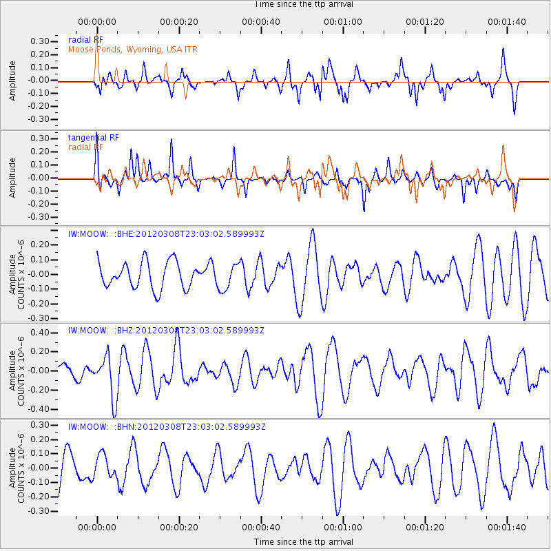
MOOW Moose Ponds, Wyoming, USA - Earthquake Result Viewer
*The percent match for this event was below the threshold and hence no stack was calculated.
| Earthquake location: |
Southern Xinjiang, China |
| Earthquake latitude/longitude: |
39.4/81.3 |
| Earthquake time(UTC): |
2012/03/08 (068) 22:50:08 GMT |
| Earthquake Depth: |
38 km |
| Earthquake Magnitude: |
5.8 MB, 5.6 MS, 5.9 MW, 5.8 MW |
| Earthquake Catalog/Contributor: |
WHDF/NEIC |
|
| Network: |
IW Intermountain West |
| Station: |
MOOW Moose Ponds, Wyoming, USA |
| Lat/Lon: |
43.75 N/110.74 W |
| Elevation: |
2128 m |
|
| Distance: |
96.5 deg |
| Az: |
8.76 deg |
| Baz: |
350.626 deg |
| Ray Param: |
$rayparam |
*The percent match for this event was below the threshold and hence was not used in the summary stack. |
|
| Radial Match: |
53.069584 % |
| Radial Bump: |
370 |
| Transverse Match: |
62.25624 % |
| Transverse Bump: |
286 |
| SOD ConfigId: |
440406 |
| Insert Time: |
2012-05-20 00:41:31.697 +0000 |
| GWidth: |
2.5 |
| Max Bumps: |
400 |
| Tol: |
0.001 |
|
Signal To Noise
| Channel | StoN | STA | LTA |
| IW:MOOW: :BHZ:20120308T23:03:02.589993Z | 3.471716 | 2.2940677E-7 | 6.607878E-8 |
| IW:MOOW: :BHN:20120308T23:03:02.589993Z | 0.7886913 | 7.772992E-8 | 9.855557E-8 |
| IW:MOOW: :BHE:20120308T23:03:02.589993Z | 0.979551 | 8.729786E-8 | 8.9120284E-8 |
| Arrivals |
| Ps | |
| PpPs | |
| PsPs/PpSs | |


