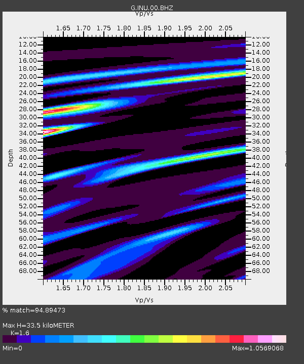
INU Inuyama, Japan - Earthquake Result Viewer

Earthquake location: Andaman Islands, India Region
Earthquake latitude/longitude: 14.1/92.9
Earthquake time(UTC): 2009/08/10 (222) 19:55:35 GMT
Earthquake Depth: 4.7 km
Earthquake Magnitude: 6.9 MB, 7.6 MS, 7.5 MW, 7.5 MW
Earthquake Catalog/Contributor: WHDF/NEIC
Network: G GEOSCOPE
Station: INU Inuyama, Japan
Lat/Lon: 35.35 N/137.03 E
Elevation: 132 m
Distance: 44.9 deg
Az: 53.788 deg
Baz: 253.265 deg
Ray Param: 0.07165919
Estimated Moho Depth: 33.5 km
Estimated Crust Vp/Vs: 1.60
Assumed Crust Vp: 6.461 km/s
Estimated Crust Vs: 4.038 km/s
Estimated Crust Poisson's Ratio: 0.18
Radial Match: 94.89473 %
Radial Bump: 400
Transverse Match: 87.94738 %
Transverse Bump: 400
SOD ConfigId: 2622
Insert Time: 2010-02-26 23:17:22.730 +0000
GWidth: 2.5
Max Bumps: 400
Tol: 0.001

Signal To Noise

ChannelStoNSTALTA
G:INU:00:BHZ:20090810T20:03:20.060012Z5.54961821.3466948E-62.426644E-7
G:INU:00:BHN:20090810T20:03:20.060012Z1.29292243.893852E-73.0116672E-7
G:INU:00:BHE:20090810T20:03:20.060012Z1.83608755.513563E-73.002887E-7
Arrivals
Ps3.3 SECOND
PpPs13 SECOND
PsPs/PpSs16 SECOND