You are here: Home > Network List > YT07 - POLENET Stations List
> Station HOWE HOWE > Earthquake Result Viewer
HOWE HOWE - Earthquake Result Viewer
| Earthquake location: |
Southeast Of Loyalty Islands |
| Earthquake latitude/longitude: |
-21.5/170.2 |
| Earthquake time(UTC): |
2014/05/01 (121) 06:36:37 GMT |
| Earthquake Depth: |
118 km |
| Earthquake Magnitude: |
6.7 MWP, 6.7 MI |
| Earthquake Catalog/Contributor: |
NEIC PDE/NEIC COMCAT |
|
| Network: |
YT POLENET |
| Station: |
HOWE HOWE |
| Lat/Lon: |
87.42 S/149.43 W |
| Elevation: |
2607 m |
|
| Distance: |
66.6 deg |
| Az: |
178.165 deg |
| Baz: |
318.945 deg |
| Ray Param: |
0.057156987 |
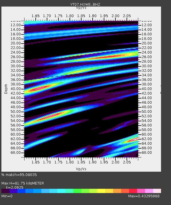
| Estimated Moho Depth: |
61.75 km |
| Estimated Crust Vp/Vs: |
2.09 |
| Assumed Crust Vp: |
6.182 km/s |
| Estimated Crust Vs: |
2.954 km/s |
| Estimated Crust Poisson's Ratio: |
0.35 |
|
| Radial Match: |
95.06835 % |
| Radial Bump: |
400 |
| Transverse Match: |
77.031876 % |
| Transverse Bump: |
400 |
| SOD ConfigId: |
3390531 |
| Insert Time: |
2019-04-11 15:55:50.254 +0000 |
| GWidth: |
2.5 |
| Max Bumps: |
400 |
| Tol: |
0.001 |
|

Signal To Noise
| Channel | StoN | STA | LTA |
| YT:HOWE: :BHZ:20140501T06:46:44.599983Z | 18.932194 | 2.1136684E-6 | 1.11644134E-7 |
| YT:HOWE: :BHN:20140501T06:46:44.599983Z | 6.8230557 | 8.042713E-7 | 1.1787552E-7 |
| YT:HOWE: :BHE:20140501T06:46:44.599983Z | 8.027675 | 7.893145E-7 | 9.8324186E-8 |
| Arrivals |
| Ps | 11 SECOND |
| PpPs | 30 SECOND |
| PsPs/PpSs | 41 SECOND |


