You are here: Home > Network List > YT07 - POLENET Stations List
> Station SIPL SIPL > Earthquake Result Viewer
SIPL SIPL - Earthquake Result Viewer
| Earthquake location: |
Southeast Of Loyalty Islands |
| Earthquake latitude/longitude: |
-21.5/170.2 |
| Earthquake time(UTC): |
2014/05/01 (121) 06:36:37 GMT |
| Earthquake Depth: |
118 km |
| Earthquake Magnitude: |
6.7 MWP, 6.7 MI |
| Earthquake Catalog/Contributor: |
NEIC PDE/NEIC COMCAT |
|
| Network: |
YT POLENET |
| Station: |
SIPL SIPL |
| Lat/Lon: |
81.64 S/148.96 W |
| Elevation: |
653 m |
|
| Distance: |
62.4 deg |
| Az: |
173.801 deg |
| Baz: |
316.595 deg |
| Ray Param: |
0.05993583 |
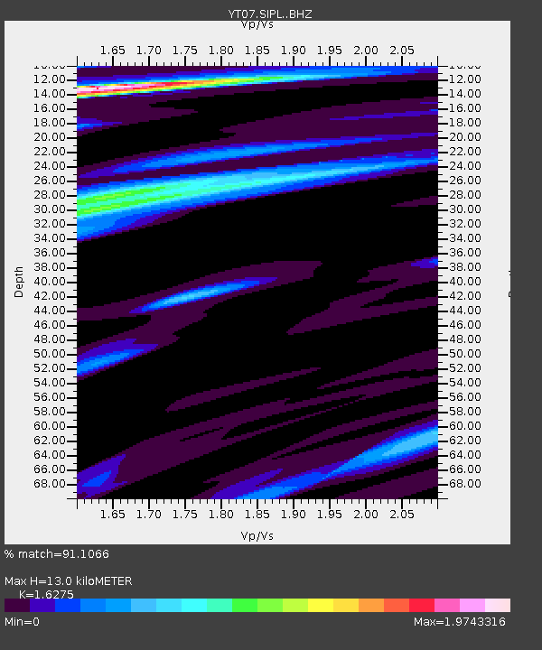
| Estimated Moho Depth: |
13.0 km |
| Estimated Crust Vp/Vs: |
1.63 |
| Assumed Crust Vp: |
6.389 km/s |
| Estimated Crust Vs: |
3.926 km/s |
| Estimated Crust Poisson's Ratio: |
0.20 |
|
| Radial Match: |
91.1066 % |
| Radial Bump: |
376 |
| Transverse Match: |
85.57946 % |
| Transverse Bump: |
400 |
| SOD ConfigId: |
3390531 |
| Insert Time: |
2019-04-11 15:55:56.816 +0000 |
| GWidth: |
2.5 |
| Max Bumps: |
400 |
| Tol: |
0.001 |
|

Signal To Noise
| Channel | StoN | STA | LTA |
| YT:SIPL: :BHZ:20140501T06:46:16.849006Z | 27.228502 | 4.127002E-6 | 1.5156918E-7 |
| YT:SIPL: :BHN:20140501T06:46:16.849006Z | 3.5769472 | 1.0912398E-6 | 3.0507573E-7 |
| YT:SIPL: :BHE:20140501T06:46:16.849006Z | 8.246442 | 1.7129396E-6 | 2.0771864E-7 |
| Arrivals |
| Ps | 1.3 SECOND |
| PpPs | 5.1 SECOND |
| PsPs/PpSs | 6.4 SECOND |


