You are here: Home > Network List > UW - Pacific Northwest Regional Seismic Network Stations List
> Station MRBL Marblemount, WA, USA > Earthquake Result Viewer
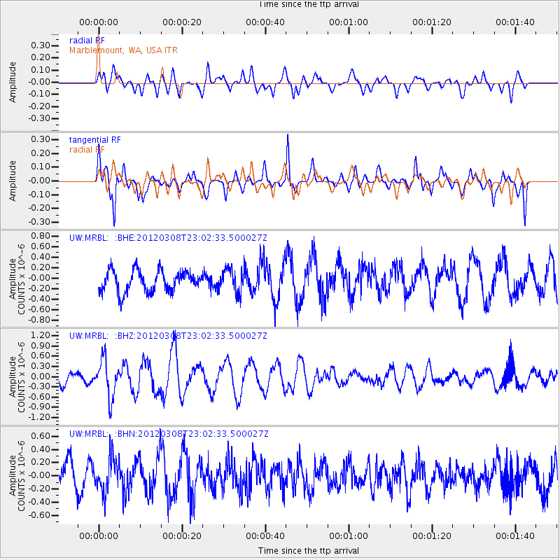
MRBL Marblemount, WA, USA - Earthquake Result Viewer
*The percent match for this event was below the threshold and hence no stack was calculated.
| Earthquake location: |
Southern Xinjiang, China |
| Earthquake latitude/longitude: |
39.4/81.3 |
| Earthquake time(UTC): |
2012/03/08 (068) 22:50:08 GMT |
| Earthquake Depth: |
38 km |
| Earthquake Magnitude: |
5.8 MB, 5.6 MS, 5.9 MW, 5.8 MW |
| Earthquake Catalog/Contributor: |
WHDF/NEIC |
|
| Network: |
UW Pacific Northwest Regional Seismic Network |
| Station: |
MRBL Marblemount, WA, USA |
| Lat/Lon: |
48.52 N/121.48 W |
| Elevation: |
75 m |
|
| Distance: |
90.2 deg |
| Az: |
14.925 deg |
| Baz: |
342.529 deg |
| Ray Param: |
$rayparam |
*The percent match for this event was below the threshold and hence was not used in the summary stack. |
|
| Radial Match: |
39.125175 % |
| Radial Bump: |
400 |
| Transverse Match: |
68.31423 % |
| Transverse Bump: |
400 |
| SOD ConfigId: |
440406 |
| Insert Time: |
2012-05-20 00:47:33.304 +0000 |
| GWidth: |
2.5 |
| Max Bumps: |
400 |
| Tol: |
0.001 |
|
Signal To Noise
| Channel | StoN | STA | LTA |
| UW:MRBL: :BHZ:20120308T23:02:33.500027Z | 2.2881002 | 5.63668E-7 | 2.4634758E-7 |
| UW:MRBL: :BHN:20120308T23:02:33.500027Z | 1.1665288 | 2.6597476E-7 | 2.280053E-7 |
| UW:MRBL: :BHE:20120308T23:02:33.500027Z | 1.1412127 | 2.242858E-7 | 1.9653285E-7 |
| Arrivals |
| Ps | |
| PpPs | |
| PsPs/PpSs | |


