You are here: Home > Network List > YB13 - Continental Dynamics/Cent. Anatolian Tectonics:Surface to Mantle Dynamics During Stations List
> Station AT40 Beyliova,Konya,Turkey > Earthquake Result Viewer
AT40 Beyliova,Konya,Turkey - Earthquake Result Viewer
| Earthquake location: |
Northern Sumatra, Indonesia |
| Earthquake latitude/longitude: |
1.9/97.9 |
| Earthquake time(UTC): |
2014/05/01 (121) 14:35:38 GMT |
| Earthquake Depth: |
55 km |
| Earthquake Magnitude: |
5.8 MWB |
| Earthquake Catalog/Contributor: |
NEIC PDE/NEIC COMCAT |
|
| Network: |
YB Continental Dynamics/Cent. Anatolian Tectonics:Surface to Mantle Dynamics During |
| Station: |
AT40 Beyliova,Konya,Turkey |
| Lat/Lon: |
38.85 N/32.45 E |
| Elevation: |
1139 m |
|
| Distance: |
69.8 deg |
| Az: |
310.81 deg |
| Baz: |
104.361 deg |
| Ray Param: |
0.055274986 |
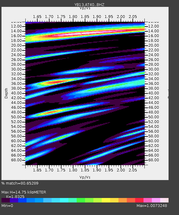
| Estimated Moho Depth: |
14.75 km |
| Estimated Crust Vp/Vs: |
1.83 |
| Assumed Crust Vp: |
6.159 km/s |
| Estimated Crust Vs: |
3.361 km/s |
| Estimated Crust Poisson's Ratio: |
0.29 |
|
| Radial Match: |
80.65289 % |
| Radial Bump: |
400 |
| Transverse Match: |
71.07307 % |
| Transverse Bump: |
400 |
| SOD ConfigId: |
3390531 |
| Insert Time: |
2019-04-11 15:59:46.297 +0000 |
| GWidth: |
2.5 |
| Max Bumps: |
400 |
| Tol: |
0.001 |
|

Signal To Noise
| Channel | StoN | STA | LTA |
| YB:AT40: :BHZ:20140501T14:46:13.118982Z | 5.2745686 | 2.7593288E-7 | 5.2313826E-8 |
| YB:AT40: :BHN:20140501T14:46:13.118982Z | 1.6911718 | 9.76004E-8 | 5.7711702E-8 |
| YB:AT40: :BHE:20140501T14:46:13.118982Z | 3.8668978 | 1.3497728E-7 | 3.490583E-8 |
| Arrivals |
| Ps | 2.1 SECOND |
| PpPs | 6.6 SECOND |
| PsPs/PpSs | 8.6 SECOND |


