You are here: Home > Network List > TA - USArray Transportable Network (new EarthScope stations) Stations List
> Station 109C Camp Elliot, Mirimar, CA, USA > Earthquake Result Viewer
109C Camp Elliot, Mirimar, CA, USA - Earthquake Result Viewer
| Earthquake location: |
Vanuatu Islands |
| Earthquake latitude/longitude: |
-19.1/169.6 |
| Earthquake time(UTC): |
2012/03/09 (069) 07:09:50 GMT |
| Earthquake Depth: |
16 km |
| Earthquake Magnitude: |
6.1 MB, 6.7 MS, 6.7 MW, 6.7 MW |
| Earthquake Catalog/Contributor: |
WHDF/NEIC |
|
| Network: |
TA USArray Transportable Network (new EarthScope stations) |
| Station: |
109C Camp Elliot, Mirimar, CA, USA |
| Lat/Lon: |
32.89 N/117.11 W |
| Elevation: |
150 m |
|
| Distance: |
87.0 deg |
| Az: |
53.799 deg |
| Baz: |
245.065 deg |
| Ray Param: |
0.043651853 |
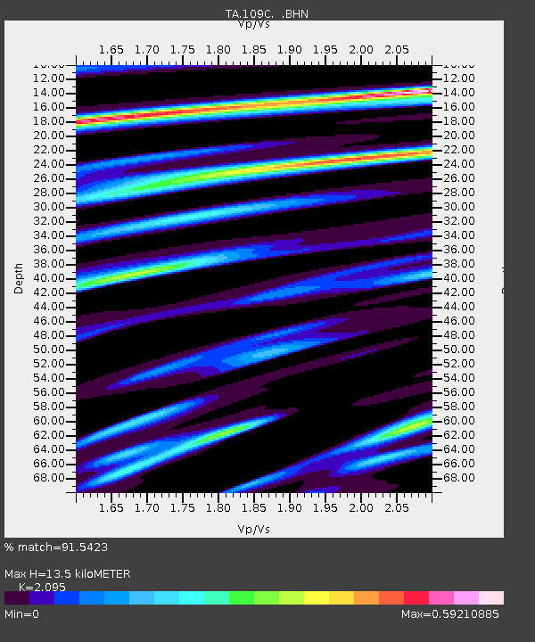
| Estimated Moho Depth: |
13.5 km |
| Estimated Crust Vp/Vs: |
2.10 |
| Assumed Crust Vp: |
6.264 km/s |
| Estimated Crust Vs: |
2.99 km/s |
| Estimated Crust Poisson's Ratio: |
0.35 |
|
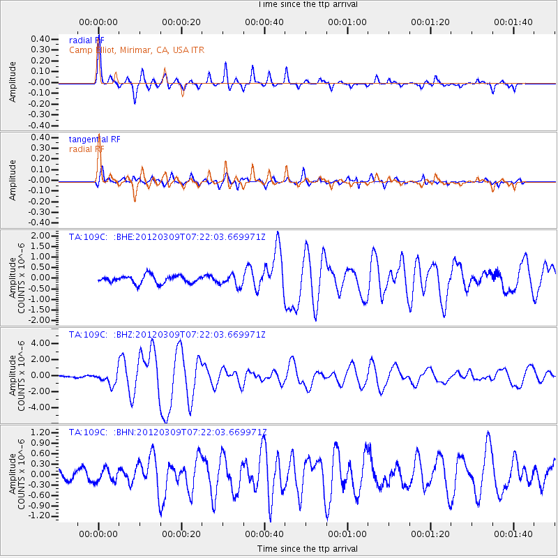
| Radial Match: |
91.5423 % |
| Radial Bump: |
261 |
| Transverse Match: |
87.8987 % |
| Transverse Bump: |
400 |
| SOD ConfigId: |
440406 |
| Insert Time: |
2012-05-20 01:01:29.727 +0000 |
| GWidth: |
2.5 |
| Max Bumps: |
400 |
| Tol: |
0.001 |
|
Signal To Noise
| Channel | StoN | STA | LTA |
| TA:109C: :BHZ:20120309T07:22:03.669971Z | 8.520694 | 8.2021336E-7 | 9.626133E-8 |
| TA:109C: :BHN:20120309T07:22:03.669971Z | 1.1965685 | 1.7945567E-7 | 1.4997526E-7 |
| TA:109C: :BHE:20120309T07:22:03.669971Z | 1.5405438 | 2.7906935E-7 | 1.811499E-7 |
| Arrivals |
| Ps | 2.4 SECOND |
| PpPs | 6.5 SECOND |
| PsPs/PpSs | 9.0 SECOND |


