You are here: Home > Network List > TA - USArray Transportable Network (new EarthScope stations) Stations List
> Station M04C Macdoel, CA, USA > Earthquake Result Viewer
M04C Macdoel, CA, USA - Earthquake Result Viewer
| Earthquake location: |
Vanuatu Islands |
| Earthquake latitude/longitude: |
-19.1/169.6 |
| Earthquake time(UTC): |
2012/03/09 (069) 07:09:50 GMT |
| Earthquake Depth: |
16 km |
| Earthquake Magnitude: |
6.1 MB, 6.7 MS, 6.7 MW, 6.7 MW |
| Earthquake Catalog/Contributor: |
WHDF/NEIC |
|
| Network: |
TA USArray Transportable Network (new EarthScope stations) |
| Station: |
M04C Macdoel, CA, USA |
| Lat/Lon: |
41.78 N/121.84 W |
| Elevation: |
1391 m |
|
| Distance: |
87.6 deg |
| Az: |
44.164 deg |
| Baz: |
241.736 deg |
| Ray Param: |
0.043222718 |
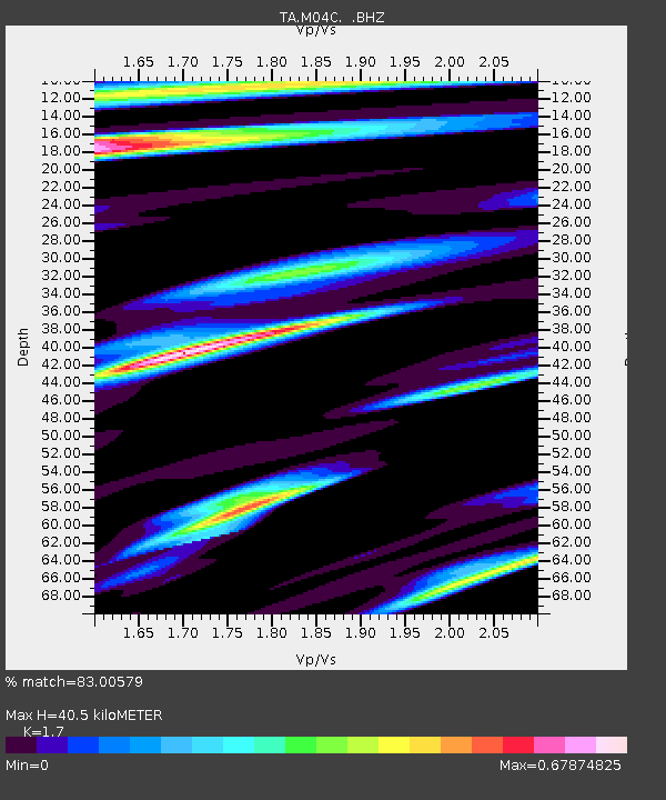
| Estimated Moho Depth: |
40.5 km |
| Estimated Crust Vp/Vs: |
1.70 |
| Assumed Crust Vp: |
6.566 km/s |
| Estimated Crust Vs: |
3.862 km/s |
| Estimated Crust Poisson's Ratio: |
0.24 |
|
| Radial Match: |
83.00579 % |
| Radial Bump: |
400 |
| Transverse Match: |
80.96797 % |
| Transverse Bump: |
400 |
| SOD ConfigId: |
440406 |
| Insert Time: |
2012-05-20 01:01:42.583 +0000 |
| GWidth: |
2.5 |
| Max Bumps: |
400 |
| Tol: |
0.001 |
|

Signal To Noise
| Channel | StoN | STA | LTA |
| TA:M04C: :BHZ:20120309T07:22:06.549976Z | 4.8231764 | 1.1644053E-6 | 2.4141875E-7 |
| TA:M04C: :BHN:20120309T07:22:06.549976Z | 3.227881 | 4.797156E-7 | 1.4861627E-7 |
| TA:M04C: :BHE:20120309T07:22:06.549976Z | 1.2413846 | 7.696881E-7 | 6.2002385E-7 |
| Arrivals |
| Ps | 4.4 SECOND |
| PpPs | 16 SECOND |
| PsPs/PpSs | 21 SECOND |


