You are here: Home > Network List > TA - USArray Transportable Network (new EarthScope stations) Stations List
> Station 121A Cookes Peak, Deming, NM, USA > Earthquake Result Viewer
121A Cookes Peak, Deming, NM, USA - Earthquake Result Viewer
*The percent match for this event was below the threshold and hence no stack was calculated.
| Earthquake location: |
Vanuatu Islands |
| Earthquake latitude/longitude: |
-19.1/169.6 |
| Earthquake time(UTC): |
2012/03/09 (069) 07:09:50 GMT |
| Earthquake Depth: |
16 km |
| Earthquake Magnitude: |
6.1 MB, 6.7 MS, 6.7 MW, 6.7 MW |
| Earthquake Catalog/Contributor: |
WHDF/NEIC |
|
| Network: |
TA USArray Transportable Network (new EarthScope stations) |
| Station: |
121A Cookes Peak, Deming, NM, USA |
| Lat/Lon: |
32.53 N/107.79 W |
| Elevation: |
1652 m |
|
| Distance: |
94.1 deg |
| Az: |
57.123 deg |
| Baz: |
250.054 deg |
| Ray Param: |
$rayparam |
*The percent match for this event was below the threshold and hence was not used in the summary stack. |
|
| Radial Match: |
79.17732 % |
| Radial Bump: |
400 |
| Transverse Match: |
69.6451 % |
| Transverse Bump: |
400 |
| SOD ConfigId: |
440406 |
| Insert Time: |
2012-05-20 01:02:24.602 +0000 |
| GWidth: |
2.5 |
| Max Bumps: |
400 |
| Tol: |
0.001 |
|
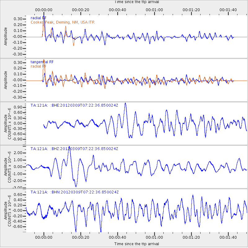
Signal To Noise
| Channel | StoN | STA | LTA |
| TA:121A: :BHZ:20120309T07:22:36.850024Z | 2.343995 | 4.905993E-7 | 2.0930048E-7 |
| TA:121A: :BHN:20120309T07:22:36.850024Z | 1.4157524 | 1.8218547E-7 | 1.2868456E-7 |
| TA:121A: :BHE:20120309T07:22:36.850024Z | 1.8326744 | 2.1417846E-7 | 1.16866616E-7 |
| Arrivals |
| Ps | |
| PpPs | |
| PsPs/PpSs | |


