You are here: Home > Network List > TA - USArray Transportable Network (new EarthScope stations) Stations List
> Station N02D Trinity Center, CA, USA > Earthquake Result Viewer
N02D Trinity Center, CA, USA - Earthquake Result Viewer
| Earthquake location: |
Vanuatu Islands |
| Earthquake latitude/longitude: |
-19.1/169.6 |
| Earthquake time(UTC): |
2012/03/09 (069) 07:09:50 GMT |
| Earthquake Depth: |
16 km |
| Earthquake Magnitude: |
6.1 MB, 6.7 MS, 6.7 MW, 6.7 MW |
| Earthquake Catalog/Contributor: |
WHDF/NEIC |
|
| Network: |
TA USArray Transportable Network (new EarthScope stations) |
| Station: |
N02D Trinity Center, CA, USA |
| Lat/Lon: |
40.97 N/122.71 W |
| Elevation: |
937 m |
|
| Distance: |
86.6 deg |
| Az: |
44.563 deg |
| Baz: |
241.186 deg |
| Ray Param: |
0.043916717 |
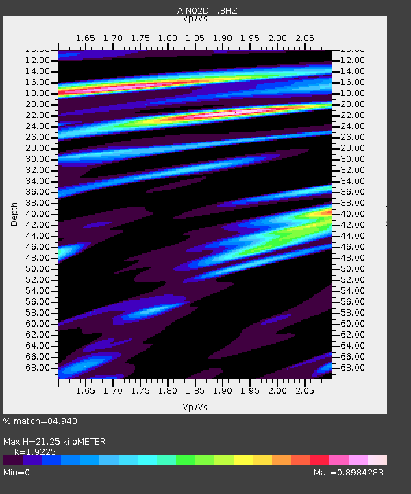
| Estimated Moho Depth: |
21.25 km |
| Estimated Crust Vp/Vs: |
1.92 |
| Assumed Crust Vp: |
6.566 km/s |
| Estimated Crust Vs: |
3.415 km/s |
| Estimated Crust Poisson's Ratio: |
0.31 |
|
| Radial Match: |
84.943 % |
| Radial Bump: |
400 |
| Transverse Match: |
87.21319 % |
| Transverse Bump: |
400 |
| SOD ConfigId: |
440406 |
| Insert Time: |
2012-05-20 01:03:16.454 +0000 |
| GWidth: |
2.5 |
| Max Bumps: |
400 |
| Tol: |
0.001 |
|
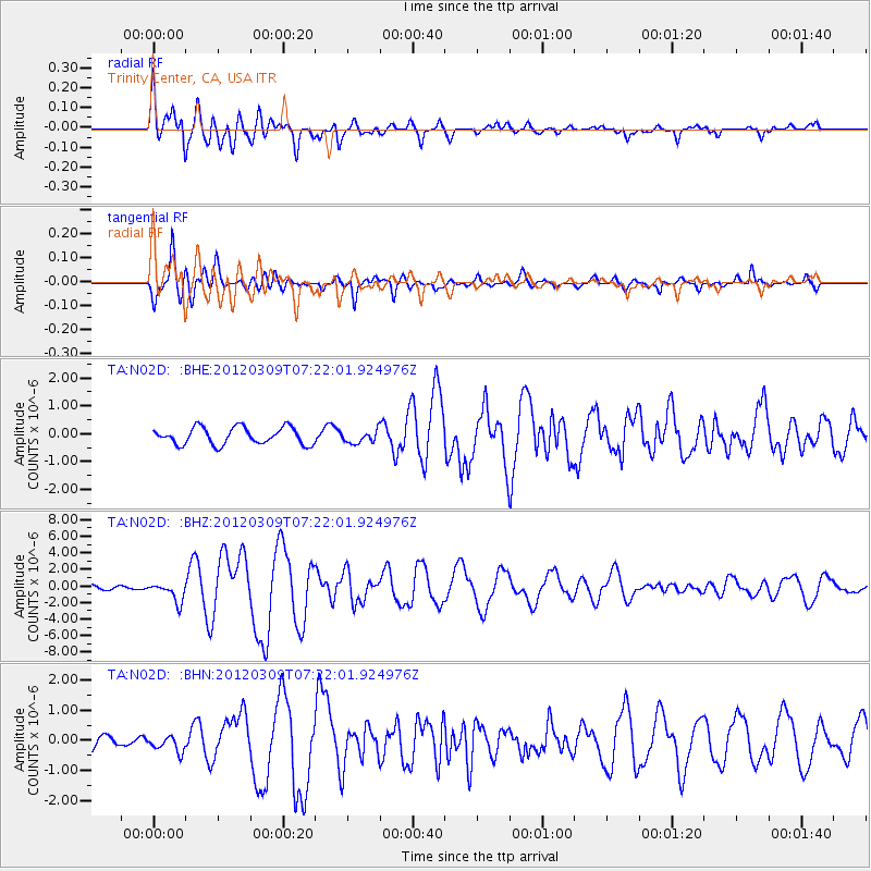
Signal To Noise
| Channel | StoN | STA | LTA |
| TA:N02D: :BHZ:20120309T07:22:01.924976Z | 4.4143705 | 1.1604678E-6 | 2.628841E-7 |
| TA:N02D: :BHN:20120309T07:22:01.924976Z | 1.0244222 | 2.507038E-7 | 2.4472706E-7 |
| TA:N02D: :BHE:20120309T07:22:01.924976Z | 0.74046737 | 2.2557046E-7 | 3.0463252E-7 |
| Arrivals |
| Ps | 3.1 SECOND |
| PpPs | 9.3 SECOND |
| PsPs/PpSs | 12 SECOND |


