You are here: Home > Network List > TA - USArray Transportable Network (new EarthScope stations) Stations List
> Station D03D Eldon, WA, USA > Earthquake Result Viewer
D03D Eldon, WA, USA - Earthquake Result Viewer
| Earthquake location: |
Vanuatu Islands |
| Earthquake latitude/longitude: |
-19.1/169.6 |
| Earthquake time(UTC): |
2012/03/09 (069) 07:09:50 GMT |
| Earthquake Depth: |
16 km |
| Earthquake Magnitude: |
6.1 MB, 6.7 MS, 6.7 MW, 6.7 MW |
| Earthquake Catalog/Contributor: |
WHDF/NEIC |
|
| Network: |
TA USArray Transportable Network (new EarthScope stations) |
| Station: |
D03D Eldon, WA, USA |
| Lat/Lon: |
47.53 N/123.09 W |
| Elevation: |
262 m |
|
| Distance: |
89.6 deg |
| Az: |
38.692 deg |
| Baz: |
240.722 deg |
| Ray Param: |
0.04175451 |
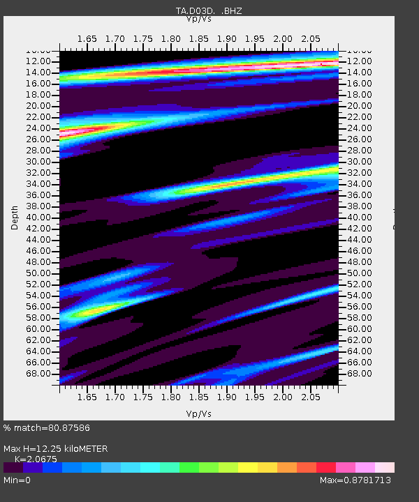
| Estimated Moho Depth: |
12.25 km |
| Estimated Crust Vp/Vs: |
2.07 |
| Assumed Crust Vp: |
6.566 km/s |
| Estimated Crust Vs: |
3.176 km/s |
| Estimated Crust Poisson's Ratio: |
0.35 |
|
| Radial Match: |
80.87586 % |
| Radial Bump: |
313 |
| Transverse Match: |
88.266754 % |
| Transverse Bump: |
327 |
| SOD ConfigId: |
440406 |
| Insert Time: |
2012-05-20 01:04:15.478 +0000 |
| GWidth: |
2.5 |
| Max Bumps: |
400 |
| Tol: |
0.001 |
|

Signal To Noise
| Channel | StoN | STA | LTA |
| TA:D03D: :BHZ:20120309T07:22:15.950Z | 3.7558522 | 1.1086391E-6 | 2.9517645E-7 |
| TA:D03D: :BHN:20120309T07:22:15.950Z | 0.9104717 | 3.4141982E-7 | 3.7499225E-7 |
| TA:D03D: :BHE:20120309T07:22:15.950Z | 0.73019713 | 2.0251761E-7 | 2.7734646E-7 |
| Arrivals |
| Ps | 2.0 SECOND |
| PpPs | 5.6 SECOND |
| PsPs/PpSs | 7.6 SECOND |


