You are here: Home > Network List > TA - USArray Transportable Network (new EarthScope stations) Stations List
> Station TPFO Pinon Flats, CA, USA > Earthquake Result Viewer
TPFO Pinon Flats, CA, USA - Earthquake Result Viewer
| Earthquake location: |
Vanuatu Islands |
| Earthquake latitude/longitude: |
-19.1/169.6 |
| Earthquake time(UTC): |
2012/03/09 (069) 07:09:50 GMT |
| Earthquake Depth: |
16 km |
| Earthquake Magnitude: |
6.1 MB, 6.7 MS, 6.7 MW, 6.7 MW |
| Earthquake Catalog/Contributor: |
WHDF/NEIC |
|
| Network: |
TA USArray Transportable Network (new EarthScope stations) |
| Station: |
TPFO Pinon Flats, CA, USA |
| Lat/Lon: |
33.61 N/116.45 W |
| Elevation: |
1275 m |
|
| Distance: |
87.8 deg |
| Az: |
53.377 deg |
| Baz: |
245.401 deg |
| Ray Param: |
0.04307564 |
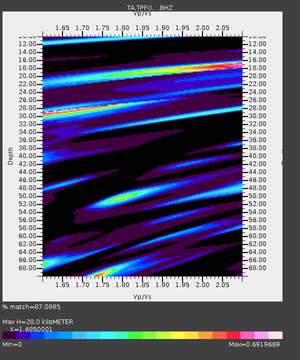
| Estimated Moho Depth: |
28.0 km |
| Estimated Crust Vp/Vs: |
1.69 |
| Assumed Crust Vp: |
6.264 km/s |
| Estimated Crust Vs: |
3.717 km/s |
| Estimated Crust Poisson's Ratio: |
0.23 |
|
| Radial Match: |
87.0895 % |
| Radial Bump: |
327 |
| Transverse Match: |
74.05912 % |
| Transverse Bump: |
318 |
| SOD ConfigId: |
440406 |
| Insert Time: |
2012-05-20 01:04:27.348 +0000 |
| GWidth: |
2.5 |
| Max Bumps: |
400 |
| Tol: |
0.001 |
|
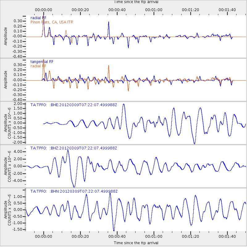
Signal To Noise
| Channel | StoN | STA | LTA |
| TA:TPFO: :BHZ:20120309T07:22:07.499988Z | 3.41661 | 8.441826E-7 | 2.470819E-7 |
| TA:TPFO: :BHN:20120309T07:22:07.499988Z | 0.8134113 | 2.0213096E-7 | 2.4849786E-7 |
| TA:TPFO: :BHE:20120309T07:22:07.499988Z | 1.4141346 | 2.6521556E-7 | 1.8754619E-7 |
| Arrivals |
| Ps | 3.1 SECOND |
| PpPs | 12 SECOND |
| PsPs/PpSs | 15 SECOND |


