You are here: Home > Network List > UW - Pacific Northwest Regional Seismic Network Stations List
> Station DDRF Dider Farm, Eltopia, WA, USA > Earthquake Result Viewer
DDRF Dider Farm, Eltopia, WA, USA - Earthquake Result Viewer
| Earthquake location: |
Vanuatu Islands |
| Earthquake latitude/longitude: |
-19.1/169.6 |
| Earthquake time(UTC): |
2012/03/09 (069) 07:09:50 GMT |
| Earthquake Depth: |
16 km |
| Earthquake Magnitude: |
6.1 MB, 6.7 MS, 6.7 MW, 6.7 MW |
| Earthquake Catalog/Contributor: |
WHDF/NEIC |
|
| Network: |
UW Pacific Northwest Regional Seismic Network |
| Station: |
DDRF Dider Farm, Eltopia, WA, USA |
| Lat/Lon: |
46.49 N/119.06 W |
| Elevation: |
233 m |
|
| Distance: |
91.5 deg |
| Az: |
40.901 deg |
| Baz: |
243.641 deg |
| Ray Param: |
0.041596133 |
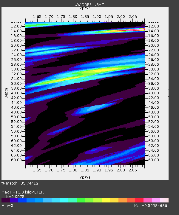
| Estimated Moho Depth: |
13.0 km |
| Estimated Crust Vp/Vs: |
2.10 |
| Assumed Crust Vp: |
6.419 km/s |
| Estimated Crust Vs: |
3.06 km/s |
| Estimated Crust Poisson's Ratio: |
0.35 |
|
| Radial Match: |
85.74412 % |
| Radial Bump: |
400 |
| Transverse Match: |
61.375225 % |
| Transverse Bump: |
379 |
| SOD ConfigId: |
440406 |
| Insert Time: |
2012-05-20 01:07:17.561 +0000 |
| GWidth: |
2.5 |
| Max Bumps: |
400 |
| Tol: |
0.001 |
|

Signal To Noise
| Channel | StoN | STA | LTA |
| UW:DDRF: :BHZ:20120309T07:22:24.975024Z | 3.5912182 | 8.9907206E-7 | 2.5035294E-7 |
| UW:DDRF: :BHN:20120309T07:22:24.975024Z | 1.5212252 | 2.6127353E-7 | 1.7175203E-7 |
| UW:DDRF: :BHE:20120309T07:22:24.975024Z | 1.0702934 | 3.304079E-7 | 3.0870777E-7 |
| Arrivals |
| Ps | 2.3 SECOND |
| PpPs | 6.2 SECOND |
| PsPs/PpSs | 8.4 SECOND |


