You are here: Home > Network List > TA - USArray Transportable Network (new EarthScope stations) Stations List
> Station L32A Elgin, NE, USA > Earthquake Result Viewer
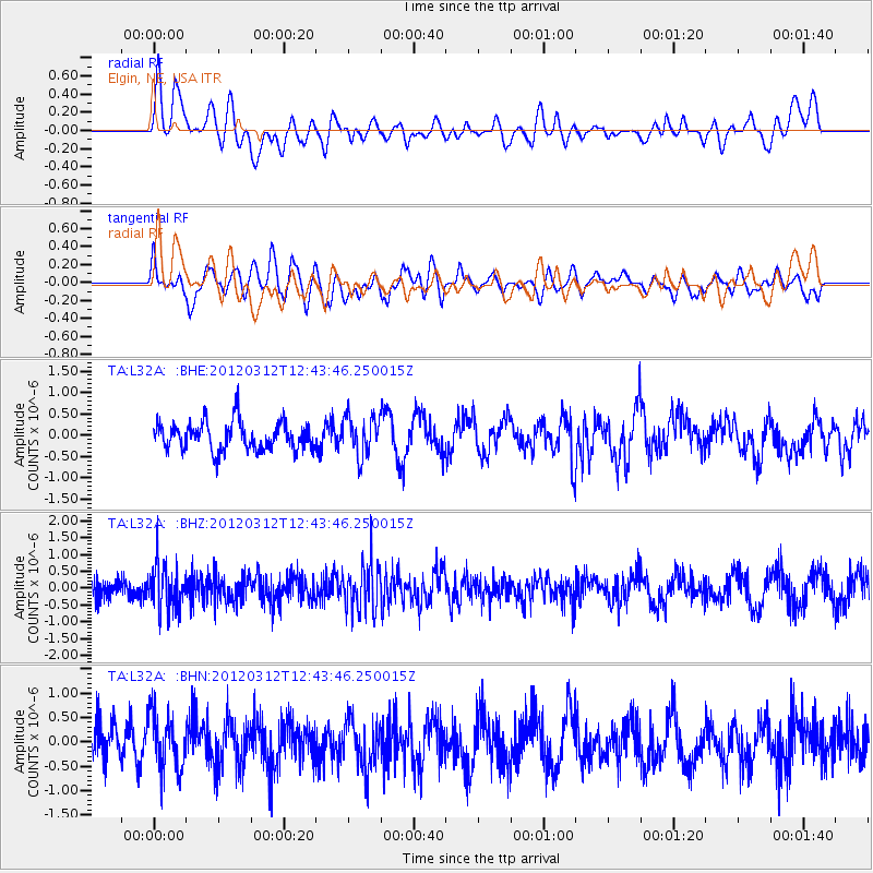
L32A Elgin, NE, USA - Earthquake Result Viewer
*The percent match for this event was below the threshold and hence no stack was calculated.
| Earthquake location: |
Kuril Islands |
| Earthquake latitude/longitude: |
45.2/147.6 |
| Earthquake time(UTC): |
2012/03/12 (072) 12:32:46 GMT |
| Earthquake Depth: |
110 km |
| Earthquake Magnitude: |
5.7 MB, 5.5 MW, 5.6 MW |
| Earthquake Catalog/Contributor: |
WHDF/NEIC |
|
| Network: |
TA USArray Transportable Network (new EarthScope stations) |
| Station: |
L32A Elgin, NE, USA |
| Lat/Lon: |
42.00 N/98.01 W |
| Elevation: |
586 m |
|
| Distance: |
75.3 deg |
| Az: |
44.583 deg |
| Baz: |
318.286 deg |
| Ray Param: |
$rayparam |
*The percent match for this event was below the threshold and hence was not used in the summary stack. |
|
| Radial Match: |
43.94208 % |
| Radial Bump: |
400 |
| Transverse Match: |
34.584194 % |
| Transverse Bump: |
400 |
| SOD ConfigId: |
440406 |
| Insert Time: |
2012-05-25 21:58:02.938 +0000 |
| GWidth: |
2.5 |
| Max Bumps: |
400 |
| Tol: |
0.001 |
|
Signal To Noise
| Channel | StoN | STA | LTA |
| TA:L32A: :BHZ:20120312T12:43:46.250015Z | 2.584538 | 6.839471E-7 | 2.6463033E-7 |
| TA:L32A: :BHN:20120312T12:43:46.250015Z | 1.327694 | 5.8935365E-7 | 4.4389267E-7 |
| TA:L32A: :BHE:20120312T12:43:46.250015Z | 1.4055434 | 4.6318743E-7 | 3.295433E-7 |
| Arrivals |
| Ps | |
| PpPs | |
| PsPs/PpSs | |


