You are here: Home > Network List > TA - USArray Transportable Network (new EarthScope stations) Stations List
> Station E31A Nome, ND, USA > Earthquake Result Viewer
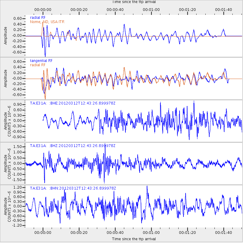
E31A Nome, ND, USA - Earthquake Result Viewer
*The percent match for this event was below the threshold and hence no stack was calculated.
| Earthquake location: |
Kuril Islands |
| Earthquake latitude/longitude: |
45.2/147.6 |
| Earthquake time(UTC): |
2012/03/12 (072) 12:32:46 GMT |
| Earthquake Depth: |
110 km |
| Earthquake Magnitude: |
5.7 MB, 5.5 MW, 5.6 MW |
| Earthquake Catalog/Contributor: |
WHDF/NEIC |
|
| Network: |
TA USArray Transportable Network (new EarthScope stations) |
| Station: |
E31A Nome, ND, USA |
| Lat/Lon: |
46.56 N/97.89 W |
| Elevation: |
427 m |
|
| Distance: |
71.9 deg |
| Az: |
41.333 deg |
| Baz: |
317.452 deg |
| Ray Param: |
$rayparam |
*The percent match for this event was below the threshold and hence was not used in the summary stack. |
|
| Radial Match: |
50.78027 % |
| Radial Bump: |
400 |
| Transverse Match: |
53.275482 % |
| Transverse Bump: |
400 |
| SOD ConfigId: |
440406 |
| Insert Time: |
2012-05-25 21:59:15.563 +0000 |
| GWidth: |
2.5 |
| Max Bumps: |
400 |
| Tol: |
0.001 |
|
Signal To Noise
| Channel | StoN | STA | LTA |
| TA:E31A: :BHZ:20120312T12:43:26.899978Z | 4.4750557 | 5.7231773E-7 | 1.2789064E-7 |
| TA:E31A: :BHN:20120312T12:43:26.899978Z | 1.0731664 | 3.331442E-7 | 3.104311E-7 |
| TA:E31A: :BHE:20120312T12:43:26.899978Z | 1.7534279 | 3.6654757E-7 | 2.0904629E-7 |
| Arrivals |
| Ps | |
| PpPs | |
| PsPs/PpSs | |


