You are here: Home > Network List > TA - USArray Transportable Network (new EarthScope stations) Stations List
> Station F31A Hecla, SD, USA > Earthquake Result Viewer
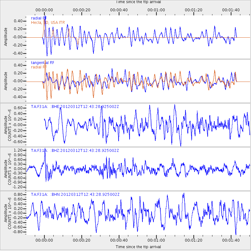
F31A Hecla, SD, USA - Earthquake Result Viewer
*The percent match for this event was below the threshold and hence no stack was calculated.
| Earthquake location: |
Kuril Islands |
| Earthquake latitude/longitude: |
45.2/147.6 |
| Earthquake time(UTC): |
2012/03/12 (072) 12:32:46 GMT |
| Earthquake Depth: |
110 km |
| Earthquake Magnitude: |
5.7 MB, 5.5 MW, 5.6 MW |
| Earthquake Catalog/Contributor: |
WHDF/NEIC |
|
| Network: |
TA USArray Transportable Network (new EarthScope stations) |
| Station: |
F31A Hecla, SD, USA |
| Lat/Lon: |
45.86 N/98.25 W |
| Elevation: |
412 m |
|
| Distance: |
72.3 deg |
| Az: |
42.026 deg |
| Baz: |
317.402 deg |
| Ray Param: |
$rayparam |
*The percent match for this event was below the threshold and hence was not used in the summary stack. |
|
| Radial Match: |
58.51693 % |
| Radial Bump: |
400 |
| Transverse Match: |
53.332138 % |
| Transverse Bump: |
400 |
| SOD ConfigId: |
440406 |
| Insert Time: |
2012-05-25 21:59:44.446 +0000 |
| GWidth: |
2.5 |
| Max Bumps: |
400 |
| Tol: |
0.001 |
|
Signal To Noise
| Channel | StoN | STA | LTA |
| TA:F31A: :BHZ:20120312T12:43:28.925002Z | 2.7739244 | 5.010392E-7 | 1.8062468E-7 |
| TA:F31A: :BHN:20120312T12:43:28.925002Z | 0.7632292 | 1.4782773E-7 | 1.9368721E-7 |
| TA:F31A: :BHE:20120312T12:43:28.925002Z | 1.518278 | 3.6283646E-7 | 2.3897894E-7 |
| Arrivals |
| Ps | |
| PpPs | |
| PsPs/PpSs | |


