You are here: Home > Network List > TA - USArray Transportable Network (new EarthScope stations) Stations List
> Station U40A Yellville, AR, USA > Earthquake Result Viewer
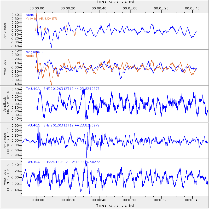
U40A Yellville, AR, USA - Earthquake Result Viewer
*The percent match for this event was below the threshold and hence no stack was calculated.
| Earthquake location: |
Kuril Islands |
| Earthquake latitude/longitude: |
45.2/147.6 |
| Earthquake time(UTC): |
2012/03/12 (072) 12:32:46 GMT |
| Earthquake Depth: |
110 km |
| Earthquake Magnitude: |
5.7 MB, 5.5 MW, 5.6 MW |
| Earthquake Catalog/Contributor: |
WHDF/NEIC |
|
| Network: |
TA USArray Transportable Network (new EarthScope stations) |
| Station: |
U40A Yellville, AR, USA |
| Lat/Lon: |
36.36 N/92.85 W |
| Elevation: |
374 m |
|
| Distance: |
82.2 deg |
| Az: |
45.151 deg |
| Baz: |
321.646 deg |
| Ray Param: |
$rayparam |
*The percent match for this event was below the threshold and hence was not used in the summary stack. |
|
| Radial Match: |
67.9685 % |
| Radial Bump: |
400 |
| Transverse Match: |
44.36969 % |
| Transverse Bump: |
400 |
| SOD ConfigId: |
440406 |
| Insert Time: |
2012-05-25 22:01:49.985 +0000 |
| GWidth: |
2.5 |
| Max Bumps: |
400 |
| Tol: |
0.001 |
|
Signal To Noise
| Channel | StoN | STA | LTA |
| TA:U40A: :BHZ:20120312T12:44:23.825027Z | 2.497714 | 3.2741872E-7 | 1.3108735E-7 |
| TA:U40A: :BHN:20120312T12:44:23.825027Z | 1.0353612 | 1.4173972E-7 | 1.368988E-7 |
| TA:U40A: :BHE:20120312T12:44:23.825027Z | 1.7037778 | 2.7172504E-7 | 1.5948385E-7 |
| Arrivals |
| Ps | |
| PpPs | |
| PsPs/PpSs | |


