You are here: Home > Network List > AE - Arizona Broadband Seismic Network Stations List
> Station U15A North Rim, AZ, USA > Earthquake Result Viewer
U15A North Rim, AZ, USA - Earthquake Result Viewer
| Earthquake location: |
Off East Coast Of Honshu, Japan |
| Earthquake latitude/longitude: |
40.9/144.9 |
| Earthquake time(UTC): |
2012/03/14 (074) 09:08:35 GMT |
| Earthquake Depth: |
12 km |
| Earthquake Magnitude: |
6.7 MB, 6.9 MS, 6.9 MW, 7.0 MW |
| Earthquake Catalog/Contributor: |
WHDF/NEIC |
|
| Network: |
AE Arizona Broadband Seismic Network |
| Station: |
U15A North Rim, AZ, USA |
| Lat/Lon: |
36.43 N/112.29 W |
| Elevation: |
2489 m |
|
| Distance: |
75.5 deg |
| Az: |
54.337 deg |
| Baz: |
310.202 deg |
| Ray Param: |
0.05162475 |
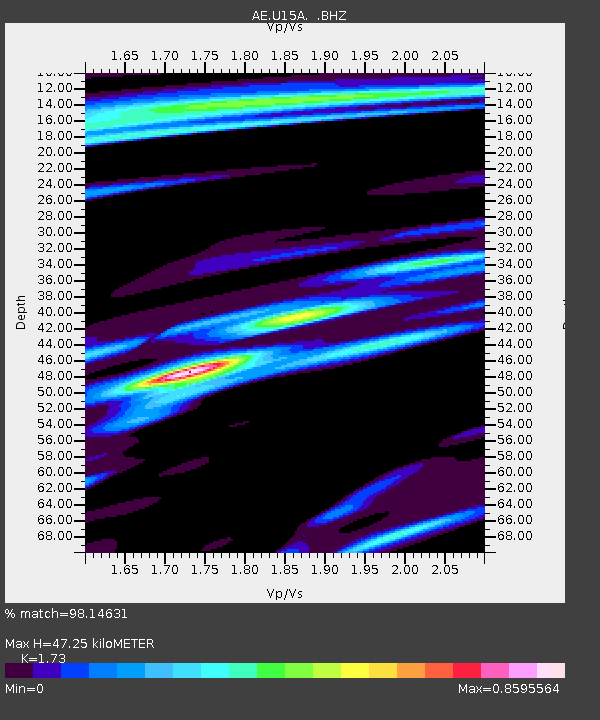
| Estimated Moho Depth: |
47.25 km |
| Estimated Crust Vp/Vs: |
1.73 |
| Assumed Crust Vp: |
6.194 km/s |
| Estimated Crust Vs: |
3.58 km/s |
| Estimated Crust Poisson's Ratio: |
0.25 |
|
| Radial Match: |
98.14631 % |
| Radial Bump: |
293 |
| Transverse Match: |
90.39982 % |
| Transverse Bump: |
400 |
| SOD ConfigId: |
440406 |
| Insert Time: |
2012-05-25 22:18:05.672 +0000 |
| GWidth: |
2.5 |
| Max Bumps: |
400 |
| Tol: |
0.001 |
|

Signal To Noise
| Channel | StoN | STA | LTA |
| AE:U15A: :BHZ:20120314T09:19:47.824998Z | 5.573157 | 1.2282205E-6 | 2.2038148E-7 |
| AE:U15A: :BHN:20120314T09:19:47.824998Z | 3.3461778 | 3.5838073E-7 | 1.0710152E-7 |
| AE:U15A: :BHE:20120314T09:19:47.824998Z | 1.9838475 | 4.0608055E-7 | 2.0469344E-7 |
| Arrivals |
| Ps | 5.7 SECOND |
| PpPs | 20 SECOND |
| PsPs/PpSs | 26 SECOND |


