SMER AZ.SMER - Earthquake Result Viewer
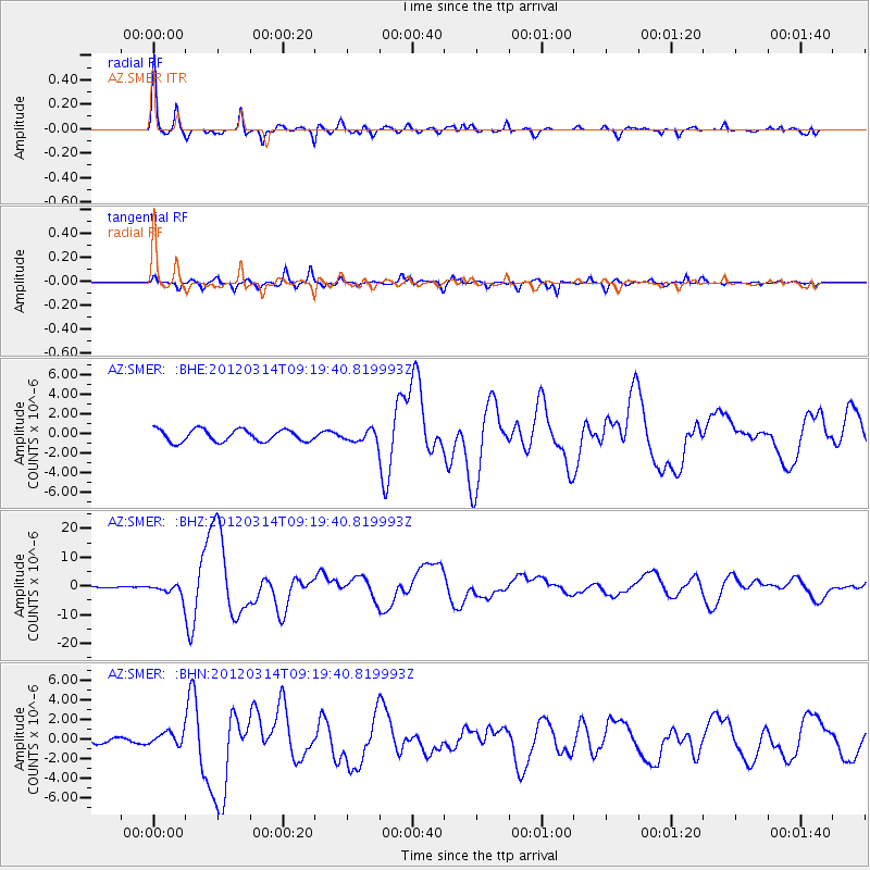
Earthquake location: Off East Coast Of Honshu, Japan
Earthquake latitude/longitude: 40.9/144.9
Earthquake time(UTC): 2012/03/14 (074) 09:08:35 GMT
Earthquake Depth: 12 km
Earthquake Magnitude: 6.7 MB, 6.9 MS, 6.9 MW, 7.0 MW
Earthquake Catalog/Contributor: WHDF/NEIC
Network: AZ ANZA Regional Network
Station: SMER AZ.SMER
Lat/Lon: 33.46 N/117.17 W
Elevation: 355 m
Distance: 74.3 deg
Az: 59.344 deg
Baz: 308.724 deg
Ray Param: 0.05243269
Estimated Moho Depth: 33.0 km
Estimated Crust Vp/Vs: 1.65
Assumed Crust Vp: 6.264 km/s
Estimated Crust Vs: 3.79 km/s
Estimated Crust Poisson's Ratio: 0.21
Radial Match: 96.27416 %
Radial Bump: 329
Transverse Match: 85.54727 %
Transverse Bump: 400
SOD ConfigId: 440406
Insert Time: 2012-05-25 22:23:20.078 +0000
GWidth: 2.5
Max Bumps: 400
Tol: 0.001

Signal To Noise

ChannelStoNSTALTA
AZ:SMER: :BHZ:20120314T09:19:40.819993Z6.95316122.1770547E-63.1310284E-7
AZ:SMER: :BHN:20120314T09:19:40.819993Z1.90157416.6265267E-73.4847585E-7
AZ:SMER: :BHE:20120314T09:19:40.819993Z0.98046385.931315E-76.0494995E-7
Arrivals
Ps3.6 SECOND
PpPs14 SECOND
PsPs/PpSs17 SECOND