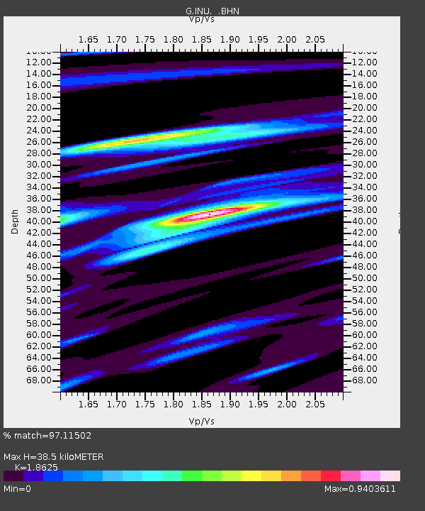
INU Inuyama, Japan - Earthquake Result Viewer

Earthquake location: New Ireland Region, P.N.G.
Earthquake latitude/longitude: -4.0/152.2
Earthquake time(UTC): 2000/11/16 (321) 04:54:56 GMT
Earthquake Depth: 33 km
Earthquake Magnitude: 6.0 MB, 8.2 MS, 8.0 MW, 8.0 ME
Earthquake Catalog/Contributor: WHDF/NEIC
Network: G GEOSCOPE
Station: INU Inuyama, Japan
Lat/Lon: 35.35 N/137.03 E
Elevation: 132 m
Distance: 41.6 deg
Az: 341.252 deg
Baz: 156.905 deg
Ray Param: 0.07360556
Estimated Moho Depth: 38.5 km
Estimated Crust Vp/Vs: 1.86
Assumed Crust Vp: 6.461 km/s
Estimated Crust Vs: 3.469 km/s
Estimated Crust Poisson's Ratio: 0.30
Radial Match: 97.11502 %
Radial Bump: 391
Transverse Match: 74.645805 %
Transverse Bump: 400
SOD ConfigId: 3744
Insert Time: 2010-02-26 23:19:05.614 +0000
GWidth: 2.5
Max Bumps: 400
Tol: 0.001

Signal To Noise

ChannelStoNSTALTA
G:INU: :BHN:20001116T05:02:11.29899Z2.67167022.7088754E-61.0139257E-6
G:INU: :BHE:20001116T05:02:11.29899Z2.0514589.770145E-74.762537E-7
G:INU: :BHZ:20001116T05:02:11.29899Z2.56645564.237023E-61.650924E-6
Arrivals
Ps5.5 SECOND
PpPs16 SECOND
PsPs/PpSs21 SECOND