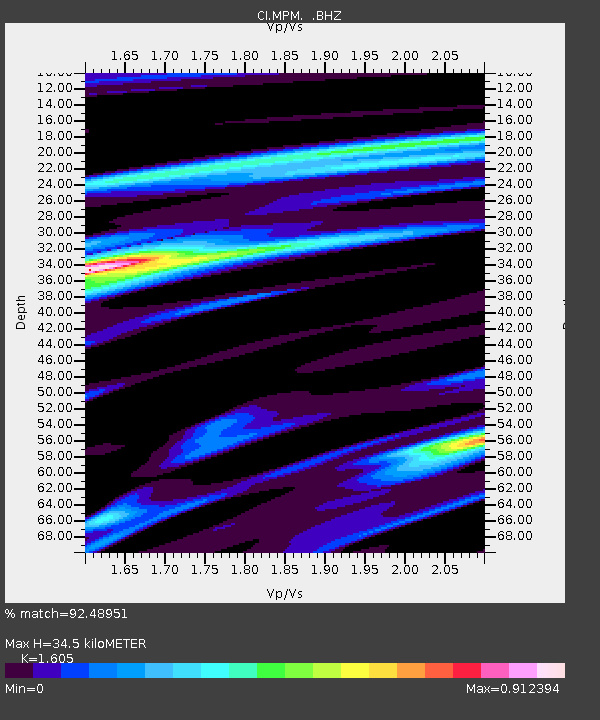
MPM Manuel Prospect Mine, California, USA - Earthquake Result Viewer
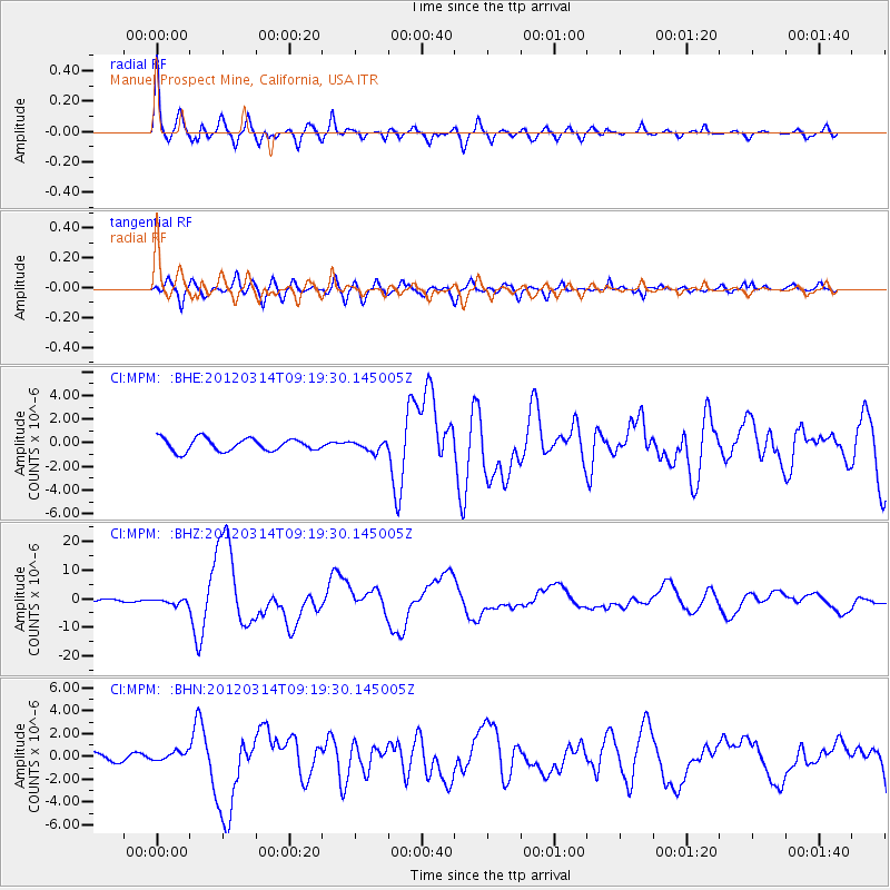
Earthquake location: Off East Coast Of Honshu, Japan
Earthquake latitude/longitude: 40.9/144.9
Earthquake time(UTC): 2012/03/14 (074) 09:08:35 GMT
Earthquake Depth: 12 km
Earthquake Magnitude: 6.7 MB, 6.9 MS, 6.9 MW, 7.0 MW
Earthquake Catalog/Contributor: WHDF/NEIC
Network: CI Caltech Regional Seismic Network
Station: MPM Manuel Prospect Mine, California, USA
Lat/Lon: 36.06 N/117.49 W
Elevation: 185 m
Distance: 72.5 deg
Az: 57.391 deg
Baz: 307.985 deg
Ray Param: 0.05363558
Estimated Moho Depth: 34.5 km
Estimated Crust Vp/Vs: 1.61
Assumed Crust Vp: 6.279 km/s
Estimated Crust Vs: 3.912 km/s
Estimated Crust Poisson's Ratio: 0.18
Radial Match: 92.48951 %
Radial Bump: 400
Transverse Match: 85.35927 %
Transverse Bump: 400
SOD ConfigId: 440406
Insert Time: 2012-05-25 22:25:25.550 +0000
GWidth: 2.5
Max Bumps: 400
Tol: 0.001

Signal To Noise

ChannelStoNSTALTA
CI:MPM: :BHZ:20120314T09:19:30.145005Z1.86342879.641024E-75.173809E-7
CI:MPM: :BHN:20120314T09:19:30.145005Z1.16467314.1128834E-73.5313627E-7
CI:MPM: :BHE:20120314T09:19:30.145005Z0.797247774.2456233E-75.32535E-7
Arrivals
Ps3.4 SECOND
PpPs14 SECOND
PsPs/PpSs17 SECOND