You are here: Home > Network List > G - GEOSCOPE Stations List
> Station INU Inuyama, Japan > Earthquake Result Viewer
INU Inuyama, Japan - Earthquake Result Viewer
| Earthquake location: |
Banda Sea |
| Earthquake latitude/longitude: |
-4.2/127.3 |
| Earthquake time(UTC): |
2000/08/28 (241) 19:29:24 GMT |
| Earthquake Depth: |
33 km |
| Earthquake Magnitude: |
6.0 MB |
| Earthquake Catalog/Contributor: |
WHDF/NEIC |
|
| Network: |
G GEOSCOPE |
| Station: |
INU Inuyama, Japan |
| Lat/Lon: |
35.35 N/137.03 E |
| Elevation: |
132 m |
|
| Distance: |
40.4 deg |
| Az: |
12.305 deg |
| Baz: |
195.072 deg |
| Ray Param: |
0.07439024 |
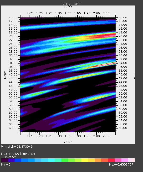
| Estimated Moho Depth: |
34.0 km |
| Estimated Crust Vp/Vs: |
2.07 |
| Assumed Crust Vp: |
6.461 km/s |
| Estimated Crust Vs: |
3.121 km/s |
| Estimated Crust Poisson's Ratio: |
0.35 |
|
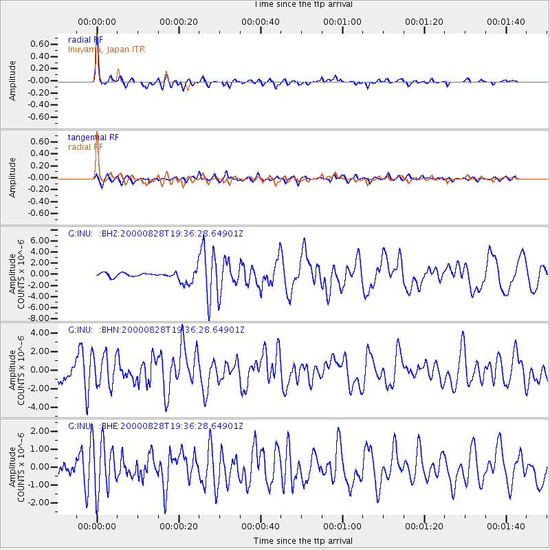
| Radial Match: |
93.473045 % |
| Radial Bump: |
297 |
| Transverse Match: |
79.41425 % |
| Transverse Bump: |
400 |
| SOD ConfigId: |
3744 |
| Insert Time: |
2010-02-26 23:19:09.101 +0000 |
| GWidth: |
2.5 |
| Max Bumps: |
400 |
| Tol: |
0.001 |
|
Signal To Noise
| Channel | StoN | STA | LTA |
| G:INU: :BHN:20000828T19:36:28.64901Z | 3.6560972 | 1.666568E-6 | 4.5583252E-7 |
| G:INU: :BHE:20000828T19:36:28.64901Z | 6.9815235 | 1.3880815E-6 | 1.9882214E-7 |
| G:INU: :BHZ:20000828T19:36:28.64901Z | 3.6064386 | 2.6434443E-6 | 7.329792E-7 |
| Arrivals |
| Ps | 6.0 SECOND |
| PpPs | 15 SECOND |
| PsPs/PpSs | 21 SECOND |


