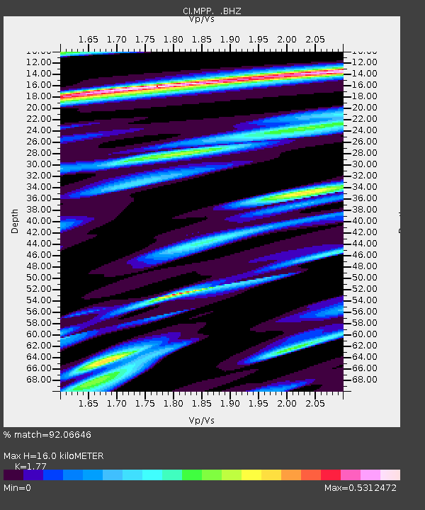
MPP McPhearson Peak - Earthquake Result Viewer
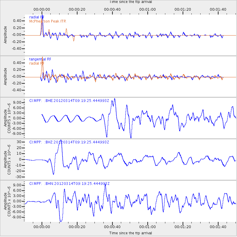
Earthquake location: Off East Coast Of Honshu, Japan
Earthquake latitude/longitude: 40.9/144.9
Earthquake time(UTC): 2012/03/14 (074) 09:08:35 GMT
Earthquake Depth: 12 km
Earthquake Magnitude: 6.7 MB, 6.9 MS, 6.9 MW, 7.0 MW
Earthquake Catalog/Contributor: WHDF/NEIC
Network: CI Caltech Regional Seismic Network
Station: MPP McPhearson Peak
Lat/Lon: 34.89 N/119.81 W
Elevation: 1739 m
Distance: 71.7 deg
Az: 59.58 deg
Baz: 307.315 deg
Ray Param: 0.05416279
Estimated Moho Depth: 16.0 km
Estimated Crust Vp/Vs: 1.77
Assumed Crust Vp: 6.1 km/s
Estimated Crust Vs: 3.446 km/s
Estimated Crust Poisson's Ratio: 0.27
Radial Match: 92.06646 %
Radial Bump: 400
Transverse Match: 86.22599 %
Transverse Bump: 400
SOD ConfigId: 440406
Insert Time: 2012-05-25 22:26:45.892 +0000
GWidth: 2.5
Max Bumps: 400
Tol: 0.001

Signal To Noise

ChannelStoNSTALTA
CI:MPP: :BHZ:20120314T09:19:25.444993Z2.7206461.4767112E-65.427796E-7
CI:MPP: :BHN:20120314T09:19:25.444993Z1.0665055.435422E-75.096481E-7
CI:MPP: :BHE:20120314T09:19:25.444993Z0.892732261.202017E-61.3464473E-6
Arrivals
Ps2.1 SECOND
PpPs7.0 SECOND
PsPs/PpSs9.1 SECOND