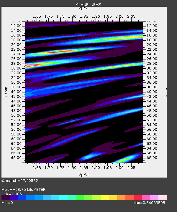
MUR Murrieta - Earthquake Result Viewer
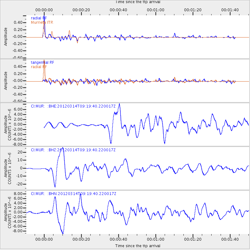
Earthquake location: Off East Coast Of Honshu, Japan
Earthquake latitude/longitude: 40.9/144.9
Earthquake time(UTC): 2012/03/14 (074) 09:08:35 GMT
Earthquake Depth: 12 km
Earthquake Magnitude: 6.7 MB, 6.9 MS, 6.9 MW, 7.0 MW
Earthquake Catalog/Contributor: WHDF/NEIC
Network: CI Caltech Regional Seismic Network
Station: MUR Murrieta
Lat/Lon: 33.60 N/117.20 W
Elevation: 562 m
Distance: 74.2 deg
Az: 59.242 deg
Baz: 308.683 deg
Ray Param: 0.05250314
Estimated Moho Depth: 28.75 km
Estimated Crust Vp/Vs: 1.61
Assumed Crust Vp: 6.264 km/s
Estimated Crust Vs: 3.903 km/s
Estimated Crust Poisson's Ratio: 0.18
Radial Match: 97.40562 %
Radial Bump: 324
Transverse Match: 84.17548 %
Transverse Bump: 400
SOD ConfigId: 440406
Insert Time: 2012-05-25 22:27:46.510 +0000
GWidth: 2.5
Max Bumps: 400
Tol: 0.001

Signal To Noise

ChannelStoNSTALTA
CI:MUR: :BHZ:20120314T09:19:40.220017Z3.41730072.1302262E-66.2336517E-7
CI:MUR: :BHN:20120314T09:19:40.220017Z1.53781185.458095E-73.549261E-7
CI:MUR: :BHE:20120314T09:19:40.220017Z0.96673435.988837E-76.194915E-7
Arrivals
Ps2.9 SECOND
PpPs12 SECOND
PsPs/PpSs14 SECOND