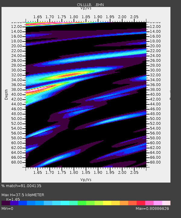
LLLB LILLOOET, BC, CANADA ADA - Earthquake Result Viewer
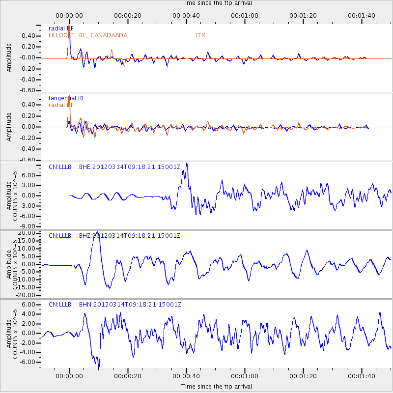
Earthquake location: Off East Coast Of Honshu, Japan
Earthquake latitude/longitude: 40.9/144.9
Earthquake time(UTC): 2012/03/14 (074) 09:08:35 GMT
Earthquake Depth: 12 km
Earthquake Magnitude: 6.7 MB, 6.9 MS, 6.9 MW, 7.0 MW
Earthquake Catalog/Contributor: WHDF/NEIC
Network: CN Canadian National Seismograph Network
Station: LLLB LILLOOET, BC, CANADA ADA
Lat/Lon: 50.61 N/121.88 W
Elevation: 700 m
Distance: 61.6 deg
Az: 46.328 deg
Baz: 300.607 deg
Ray Param: 0.060773868
Estimated Moho Depth: 37.5 km
Estimated Crust Vp/Vs: 1.65
Assumed Crust Vp: 6.597 km/s
Estimated Crust Vs: 3.998 km/s
Estimated Crust Poisson's Ratio: 0.21
Radial Match: 91.004135 %
Radial Bump: 400
Transverse Match: 77.84714 %
Transverse Bump: 400
SOD ConfigId: 440406
Insert Time: 2012-05-25 22:30:14.753 +0000
GWidth: 2.5
Max Bumps: 400
Tol: 0.001

Signal To Noise

ChannelStoNSTALTA
CN:LLLB: :BHZ:20120314T09:18:21.15001Z5.67252162.1216258E-63.7401813E-7
CN:LLLB: :BHN:20120314T09:18:21.15001Z2.11873726.548254E-73.0906398E-7
CN:LLLB: :BHE:20120314T09:18:21.15001Z1.07553556.38255E-75.9343E-7
Arrivals
Ps3.9 SECOND
PpPs14 SECOND
PsPs/PpSs18 SECOND