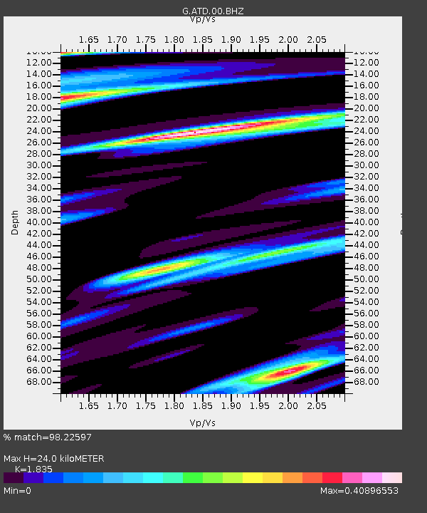
ATD Arta Cave - Arta, Republic of Djibouti - Earthquake Result Viewer
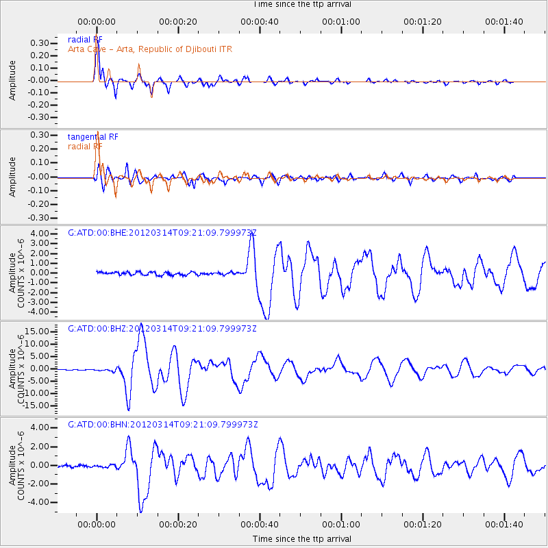
Earthquake location: Off East Coast Of Honshu, Japan
Earthquake latitude/longitude: 40.9/144.9
Earthquake time(UTC): 2012/03/14 (074) 09:08:35 GMT
Earthquake Depth: 12 km
Earthquake Magnitude: 6.7 MB, 6.9 MS, 6.9 MW, 7.0 MW
Earthquake Catalog/Contributor: WHDF/NEIC
Network: G GEOSCOPE
Station: ATD Arta Cave - Arta, Republic of Djibouti
Lat/Lon: 11.53 N/42.85 E
Elevation: 610 m
Distance: 91.5 deg
Az: 286.535 deg
Baz: 47.867 deg
Ray Param: 0.041597113
Estimated Moho Depth: 24.0 km
Estimated Crust Vp/Vs: 1.84
Assumed Crust Vp: 6.375 km/s
Estimated Crust Vs: 3.474 km/s
Estimated Crust Poisson's Ratio: 0.29
Radial Match: 98.22597 %
Radial Bump: 339
Transverse Match: 90.9355 %
Transverse Bump: 400
SOD ConfigId: 440406
Insert Time: 2012-05-25 22:31:16.303 +0000
GWidth: 2.5
Max Bumps: 400
Tol: 0.001

Signal To Noise

ChannelStoNSTALTA
G:ATD:00:BHZ:20120314T09:21:09.799973Z3.75905444.4706167E-71.18929286E-7
G:ATD:00:BHN:20120314T09:21:09.799973Z0.87099761.2402782E-71.4239744E-7
G:ATD:00:BHE:20120314T09:21:09.799973Z0.76926241.1652468E-71.5147586E-7
Arrivals
Ps3.2 SECOND
PpPs10 SECOND
PsPs/PpSs14 SECOND