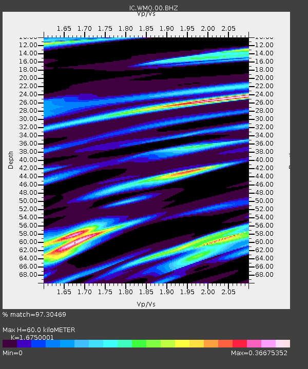
WMQ Urumqi, Xinjiang Province, China - Earthquake Result Viewer
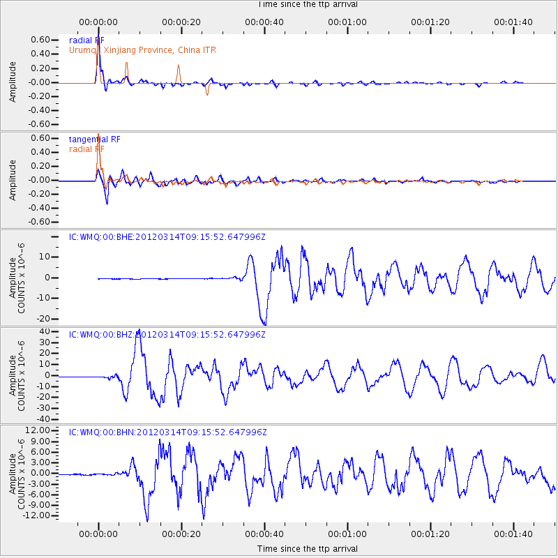
Earthquake location: Off East Coast Of Honshu, Japan
Earthquake latitude/longitude: 40.9/144.9
Earthquake time(UTC): 2012/03/14 (074) 09:08:35 GMT
Earthquake Depth: 12 km
Earthquake Magnitude: 6.7 MB, 6.9 MS, 6.9 MW, 7.0 MW
Earthquake Catalog/Contributor: WHDF/NEIC
Network: IC New China Digital Seismograph Network
Station: WMQ Urumqi, Xinjiang Province, China
Lat/Lon: 43.81 N/87.70 E
Elevation: 850 m
Distance: 41.7 deg
Az: 293.731 deg
Baz: 73.489 deg
Ray Param: 0.07363281
Estimated Moho Depth: 60.0 km
Estimated Crust Vp/Vs: 1.68
Assumed Crust Vp: 6.242 km/s
Estimated Crust Vs: 3.727 km/s
Estimated Crust Poisson's Ratio: 0.22
Radial Match: 97.30469 %
Radial Bump: 285
Transverse Match: 93.27807 %
Transverse Bump: 400
SOD ConfigId: 440406
Insert Time: 2012-05-25 22:32:37.806 +0000
GWidth: 2.5
Max Bumps: 400
Tol: 0.001

Signal To Noise

ChannelStoNSTALTA
IC:WMQ:00:BHZ:20120314T09:15:52.647996Z10.526049.171012E-78.71269E-8
IC:WMQ:00:BHN:20120314T09:15:52.647996Z2.6001952.4957515E-79.5983246E-8
IC:WMQ:00:BHE:20120314T09:15:52.647996Z5.25092554.6937907E-78.938978E-8
Arrivals
Ps6.9 SECOND
PpPs24 SECOND
PsPs/PpSs31 SECOND