You are here: Home > Network List > IW - Intermountain West Stations List
> Station DLMT Dillon, Montana, USA > Earthquake Result Viewer
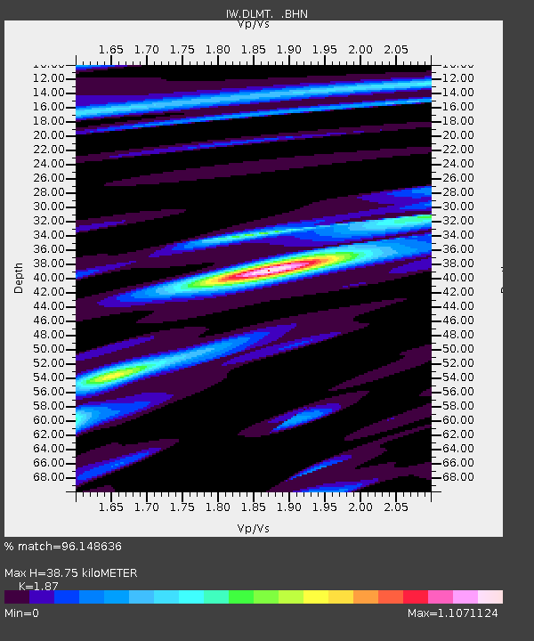
DLMT Dillon, Montana, USA - Earthquake Result Viewer
| Earthquake location: |
Off East Coast Of Honshu, Japan |
| Earthquake latitude/longitude: |
40.9/144.9 |
| Earthquake time(UTC): |
2012/03/14 (074) 09:08:35 GMT |
| Earthquake Depth: |
12 km |
| Earthquake Magnitude: |
6.7 MB, 6.9 MS, 6.9 MW, 7.0 MW |
| Earthquake Catalog/Contributor: |
WHDF/NEIC |
|
| Network: |
IW Intermountain West |
| Station: |
DLMT Dillon, Montana, USA |
| Lat/Lon: |
45.36 N/112.60 W |
| Elevation: |
1569 m |
|
| Distance: |
69.7 deg |
| Az: |
47.226 deg |
| Baz: |
307.871 deg |
| Ray Param: |
0.055476382 |
| Estimated Moho Depth: |
38.75 km |
| Estimated Crust Vp/Vs: |
1.87 |
| Assumed Crust Vp: |
6.577 km/s |
| Estimated Crust Vs: |
3.517 km/s |
| Estimated Crust Poisson's Ratio: |
0.30 |
|
| Radial Match: |
96.148636 % |
| Radial Bump: |
400 |
| Transverse Match: |
85.1753 % |
| Transverse Bump: |
400 |
| SOD ConfigId: |
440406 |
| Insert Time: |
2012-05-25 22:34:23.803 +0000 |
| GWidth: |
2.5 |
| Max Bumps: |
400 |
| Tol: |
0.001 |
|

Signal To Noise
| Channel | StoN | STA | LTA |
| IW:DLMT: :BHZ:20120314T09:19:13.340012Z | 7.6983886 | 1.4186278E-6 | 1.8427593E-7 |
| IW:DLMT: :BHN:20120314T09:19:13.340012Z | 2.3024352 | 5.505685E-7 | 2.3912443E-7 |
| IW:DLMT: :BHE:20120314T09:19:13.340012Z | 2.6658828 | 6.725953E-7 | 2.522974E-7 |
| Arrivals |
| Ps | 5.3 SECOND |
| PpPs | 16 SECOND |
| PsPs/PpSs | 22 SECOND |


