You are here: Home > Network List > TA - USArray Transportable Network (new EarthScope stations) Stations List
> Station WHTX Lake Whitney, Meridian, TX, USA > Earthquake Result Viewer
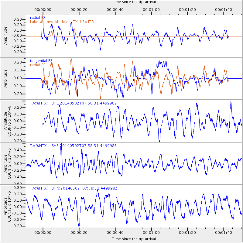
WHTX Lake Whitney, Meridian, TX, USA - Earthquake Result Viewer
*The percent match for this event was below the threshold and hence no stack was calculated.
| Earthquake location: |
Tonga Islands |
| Earthquake latitude/longitude: |
-18.8/-175.3 |
| Earthquake time(UTC): |
2014/05/02 (122) 07:46:04 GMT |
| Earthquake Depth: |
18 km |
| Earthquake Magnitude: |
5.6 MW |
| Earthquake Catalog/Contributor: |
ISC/ISC |
|
| Network: |
TA USArray Transportable Network (new EarthScope stations) |
| Station: |
WHTX Lake Whitney, Meridian, TX, USA |
| Lat/Lon: |
31.99 N/97.46 W |
| Elevation: |
190 m |
|
| Distance: |
89.9 deg |
| Az: |
56.163 deg |
| Baz: |
247.846 deg |
| Ray Param: |
$rayparam |
*The percent match for this event was below the threshold and hence was not used in the summary stack. |
|
| Radial Match: |
59.05581 % |
| Radial Bump: |
400 |
| Transverse Match: |
34.928047 % |
| Transverse Bump: |
400 |
| SOD ConfigId: |
3390531 |
| Insert Time: |
2019-04-11 16:18:03.775 +0000 |
| GWidth: |
2.5 |
| Max Bumps: |
400 |
| Tol: |
0.001 |
|
Signal To Noise
| Channel | StoN | STA | LTA |
| TA:WHTX: :BHZ:20140502T07:58:31.449998Z | 1.7414997 | 1.17236816E-7 | 6.7319455E-8 |
| TA:WHTX: :BHN:20140502T07:58:31.449998Z | 1.19731 | 1.2757934E-7 | 1.06554985E-7 |
| TA:WHTX: :BHE:20140502T07:58:31.449998Z | 0.7751729 | 7.310378E-8 | 9.4306415E-8 |
| Arrivals |
| Ps | |
| PpPs | |
| PsPs/PpSs | |


