You are here: Home > Network List > US - United States National Seismic Network Stations List
> Station WMOK Wichita Mountains, Oklahoma, USA > Earthquake Result Viewer
WMOK Wichita Mountains, Oklahoma, USA - Earthquake Result Viewer
*The percent match for this event was below the threshold and hence no stack was calculated.
| Earthquake location: |
Tonga Islands |
| Earthquake latitude/longitude: |
-18.8/-175.3 |
| Earthquake time(UTC): |
2014/05/02 (122) 07:46:04 GMT |
| Earthquake Depth: |
18 km |
| Earthquake Magnitude: |
5.6 MW |
| Earthquake Catalog/Contributor: |
ISC/ISC |
|
| Network: |
US United States National Seismic Network |
| Station: |
WMOK Wichita Mountains, Oklahoma, USA |
| Lat/Lon: |
34.74 N/98.78 W |
| Elevation: |
486 m |
|
| Distance: |
90.0 deg |
| Az: |
53.208 deg |
| Baz: |
247.118 deg |
| Ray Param: |
$rayparam |
*The percent match for this event was below the threshold and hence was not used in the summary stack. |
|
| Radial Match: |
61.08557 % |
| Radial Bump: |
400 |
| Transverse Match: |
55.874493 % |
| Transverse Bump: |
400 |
| SOD ConfigId: |
3390531 |
| Insert Time: |
2019-04-11 16:18:34.201 +0000 |
| GWidth: |
2.5 |
| Max Bumps: |
400 |
| Tol: |
0.001 |
|
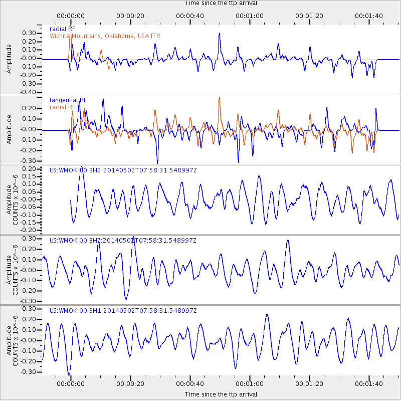
Signal To Noise
| Channel | StoN | STA | LTA |
| US:WMOK:00:BHZ:20140502T07:58:31.548997Z | 0.46674323 | 6.573807E-8 | 1.4084418E-7 |
| US:WMOK:00:BH1:20140502T07:58:31.548997Z | 1.7880167 | 1.7716658E-7 | 9.908553E-8 |
| US:WMOK:00:BH2:20140502T07:58:31.548997Z | 0.8059317 | 6.3197824E-8 | 7.841585E-8 |
| Arrivals |
| Ps | |
| PpPs | |
| PsPs/PpSs | |


