You are here: Home > Network List > CB - China National Seismic Network Stations List
> Station HEH Heihe,Heilongjiang Province > Earthquake Result Viewer
HEH Heihe,Heilongjiang Province - Earthquake Result Viewer

| Earthquake location: |
Seram, Indonesia |
| Earthquake latitude/longitude: |
-3.8/127.4 |
| Earthquake time(UTC): |
2014/05/02 (122) 08:43:37 GMT |
| Earthquake Depth: |
54 km |
| Earthquake Magnitude: |
6.0 MWP |
| Earthquake Catalog/Contributor: |
NEIC PDE/NEIC COMCAT |
|
| Network: |
CB China National Seismic Network |
| Station: |
HEH Heihe,Heilongjiang Province |
| Lat/Lon: |
50.25 N/127.41 E |
| Elevation: |
165 m |
|
| Distance: |
53.8 deg |
| Az: |
359.98 deg |
| Baz: |
179.969 deg |
| Ray Param: |
0.06569017 |
| Estimated Moho Depth: |
10.0 km |
| Estimated Crust Vp/Vs: |
1.87 |
| Assumed Crust Vp: |
6.419 km/s |
| Estimated Crust Vs: |
3.428 km/s |
| Estimated Crust Poisson's Ratio: |
0.30 |
|
| Radial Match: |
93.06986 % |
| Radial Bump: |
338 |
| Transverse Match: |
75.85699 % |
| Transverse Bump: |
400 |
| SOD ConfigId: |
3390531 |
| Insert Time: |
2019-04-11 16:20:15.911 +0000 |
| GWidth: |
2.5 |
| Max Bumps: |
400 |
| Tol: |
0.001 |
|
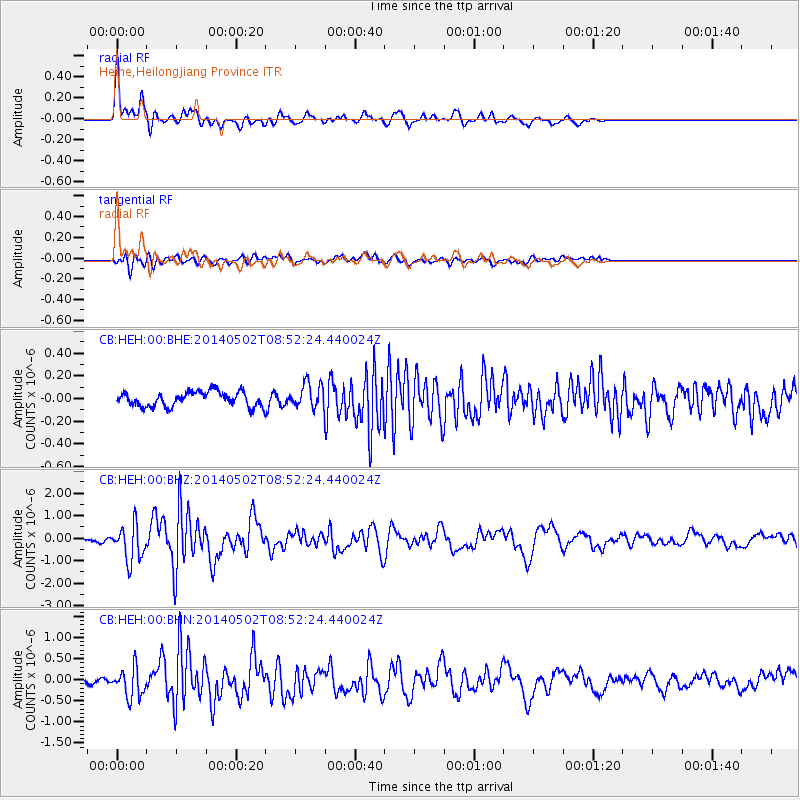
Signal To Noise
| Channel | StoN | STA | LTA |
| CB:HEH:00:BHZ:20140502T08:52:24.440024Z | 13.758194 | 8.0392925E-7 | 5.843276E-8 |
| CB:HEH:00:BHN:20140502T08:52:24.440024Z | 5.919864 | 3.4990742E-7 | 5.9107343E-8 |
| CB:HEH:00:BHE:20140502T08:52:24.440024Z | 1.6789877 | 1.0722423E-7 | 6.386243E-8 |
| Arrivals |
| Ps | 1.4 SECOND |
| PpPs | 4.3 SECOND |
| PsPs/PpSs | 5.7 SECOND |


