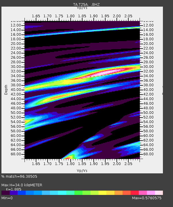
T25A Trinidad, CO, USA - Earthquake Result Viewer
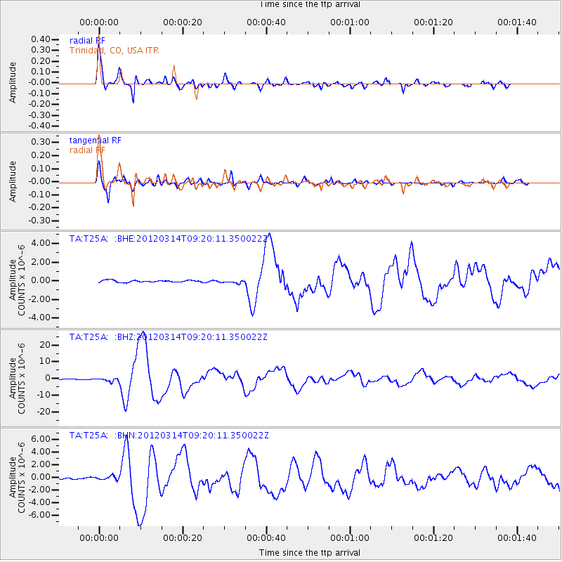
Earthquake location: Off East Coast Of Honshu, Japan
Earthquake latitude/longitude: 40.9/144.9
Earthquake time(UTC): 2012/03/14 (074) 09:08:35 GMT
Earthquake Depth: 12 km
Earthquake Magnitude: 6.7 MB, 6.9 MS, 6.9 MW, 7.0 MW
Earthquake Catalog/Contributor: WHDF/NEIC
Network: TA USArray Transportable Network (new EarthScope stations)
Station: T25A Trinidad, CO, USA
Lat/Lon: 37.14 N/104.41 W
Elevation: 2017 m
Distance: 79.7 deg
Az: 49.463 deg
Baz: 313.859 deg
Ray Param: 0.048760608
Estimated Moho Depth: 34.0 km
Estimated Crust Vp/Vs: 1.88
Assumed Crust Vp: 6.316 km/s
Estimated Crust Vs: 3.35 km/s
Estimated Crust Poisson's Ratio: 0.30
Radial Match: 96.38505 %
Radial Bump: 400
Transverse Match: 95.853775 %
Transverse Bump: 400
SOD ConfigId: 440406
Insert Time: 2012-05-25 22:42:30.423 +0000
GWidth: 2.5
Max Bumps: 400
Tol: 0.001

Signal To Noise

ChannelStoNSTALTA
TA:T25A: :BHZ:20120314T09:20:11.350022Z4.2715671.0276954E-62.4058977E-7
TA:T25A: :BHN:20120314T09:20:11.350022Z2.26807432.8409883E-71.2525993E-7
TA:T25A: :BHE:20120314T09:20:11.350022Z1.62705891.647474E-71.01254734E-7
Arrivals
Ps4.9 SECOND
PpPs15 SECOND
PsPs/PpSs20 SECOND