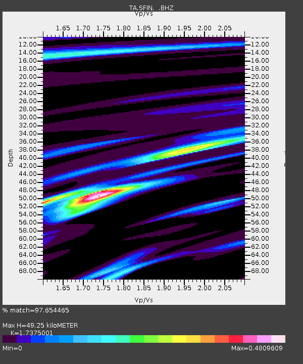
SFIN Lafayette, IN, USA - Earthquake Result Viewer

Earthquake location: Off East Coast Of Honshu, Japan
Earthquake latitude/longitude: 40.9/144.9
Earthquake time(UTC): 2012/03/14 (074) 09:08:35 GMT
Earthquake Depth: 12 km
Earthquake Magnitude: 6.7 MB, 6.9 MS, 6.9 MW, 7.0 MW
Earthquake Catalog/Contributor: WHDF/NEIC
Network: TA USArray Transportable Network (new EarthScope stations)
Station: SFIN Lafayette, IN, USA
Lat/Lon: 40.38 N/87.10 W
Elevation: 165 m
Distance: 86.3 deg
Az: 37.126 deg
Baz: 323.2 deg
Ray Param: 0.0441462
Estimated Moho Depth: 49.25 km
Estimated Crust Vp/Vs: 1.74
Assumed Crust Vp: 6.498 km/s
Estimated Crust Vs: 3.74 km/s
Estimated Crust Poisson's Ratio: 0.25
Radial Match: 97.654465 %
Radial Bump: 231
Transverse Match: 94.07098 %
Transverse Bump: 400
SOD ConfigId: 440406
Insert Time: 2012-05-25 22:43:18.617 +0000
GWidth: 2.5
Max Bumps: 400
Tol: 0.001

Signal To Noise

ChannelStoNSTALTA
TA:SFIN: :BHZ:20120314T09:20:45.249985Z23.1846713.0840006E-61.3301894E-7
TA:SFIN: :BHN:20120314T09:20:45.249985Z5.37006866.6440924E-71.2372453E-7
TA:SFIN: :BHE:20120314T09:20:45.249985Z2.80537774.041551E-71.4406442E-7
Arrivals
Ps5.7 SECOND
PpPs20 SECOND
PsPs/PpSs26 SECOND